The post Going underground #1 – flint and brick first appeared on Metageologist.
]]>We’ll start from my house, in an unremarkable suburb of Reading, an almost-city in the Thames Valley, west of London, England.
Put a spade into the ground in my back garden and it sinks in gratefully. This is well-cultivated soil, dug for Britain during the war. The stones within it are mostly flint, occasionally fossils and mostly rounded. Immediately below the soil is a gravel terrace laid down by the River Thames.

This gravel is extremely useful in construction and widely extracted. A map of Reading shows many bodies of water, dug for the gravel. The entire area is covered in these terraces, of various ages. The further up and away from the modern river you go, the older the terraces – they trace how the river has slowly cut its way into the landscape.
My house is not so close to the river, so the gravels are about 250 – 300,000 years old, a time a few ice ages past, when humans had learned to make fire and stone tools. A gravel pit behind my house unearthed some of these tools, now in Reading museum.
We’ve travelled just 6 metres. Below the gravels we get the first ‘solid’ geology – the London Clay and Lambeth Group, layers of sand, silt and mud around 50-60 million years old. Dramatic things were happening at this time – huge volcanoes formed in the west of Scotland, India first collided with Asia to form the mighty Himalayan mountains. In SE England alas, not much was going on, just a bunch of mud and sand being draped over the surface.
What’s most interesting about these rocks is what people did with them. Particular layers are good for making bricks and this has shaped the local area. Reading town centre is full of fine Victorian brick-buildings. The local clay gives red bricks, but mixing in quantities of chalk gave a grey coloured brick. Bricks were made across the Thames Valley, wherever suitable clay was found.
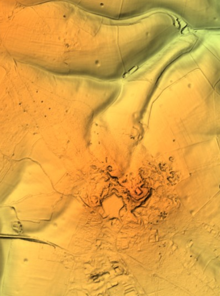
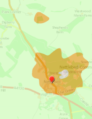
Unlike older, more deeply buried sediments, these rocks are still soft and poorly bound together, something that led to the first ever serious railway accident. The Great Western Railway was originally planned to run through the village of Sonning, close to the Thames. However an uncooperative land-owner forced the route to go through a small hill. Any plans to tunnel through were dashed by the low strength of the sediments. Instead a cutting was made – a 17m deep gash through the hill – with the railway running at the bottom of it. On the 24th December 1841, a landslip covered the rails with ‘soil’. A train ran into the slip, causing the deaths of 9 people. These were early days for both railways and engineering geology – the cutting was later widened, making the slopes less steep.

Only 24m below my house, we reach the Chalk. This is a rock-type that is both an icon of Southern England (“white cliffs of Dover”) and deeply weird.
While most sedimentary rocks are made of sand or mud, chalk is almost entirely made up of the remains of living creatures. Sea-levels at the time (95-65 million years ago) were extremely high, meaning much of Britain was underwater. Since little or no sand or mud was being washed into the sea, the only things settling on the sea-bed were the remains of tiny planktonic organisms. These grew tiny beautifully shaped flakes of calcium carbonate that found their way to the sea-bed, building up layer after layer. Other creatures, like sea urchins living in this chalky mud had parts made of silica. These formed into nodules black flint, so prized by our distant ancestors. Rare stones are found in the chalk, thought to have polished in the insides of giant sea monsters, marine reptiles that swam these seas.
Chalk landscapes form the bones of southern England. Slightly harder, they form ridges such as the Chilterns and South Downs. These are strange landscapes, dotted by prehistoric structures and mysterious figures formed by cutting through the thin soils to reveal the pure white chalk beneath.
These chalk hills have sinuous valleys and whale-backed hills. The valleys are dry – chalk is a rock that swallows rivers and is in turn dissolved by water. Near me, above the chalk, a swallow hole recently appeared in a school car park, a reminder of the chasms beneath our feet.
There are creatures beneath my feet. The chalk aquifers are home to creatures called stygobites, ghostly crustacean that eke out a living in wet cracks. Some are thought to have been living in England for up to 19 million years, making them our longest continuous inhabitant
The remains of more ancient life lies deeper still. As we shall see, next time.
The post Going underground #1 – flint and brick first appeared on Metageologist.
]]>The post Assynt’s etched landscape first appeared on Metageologist.
]]>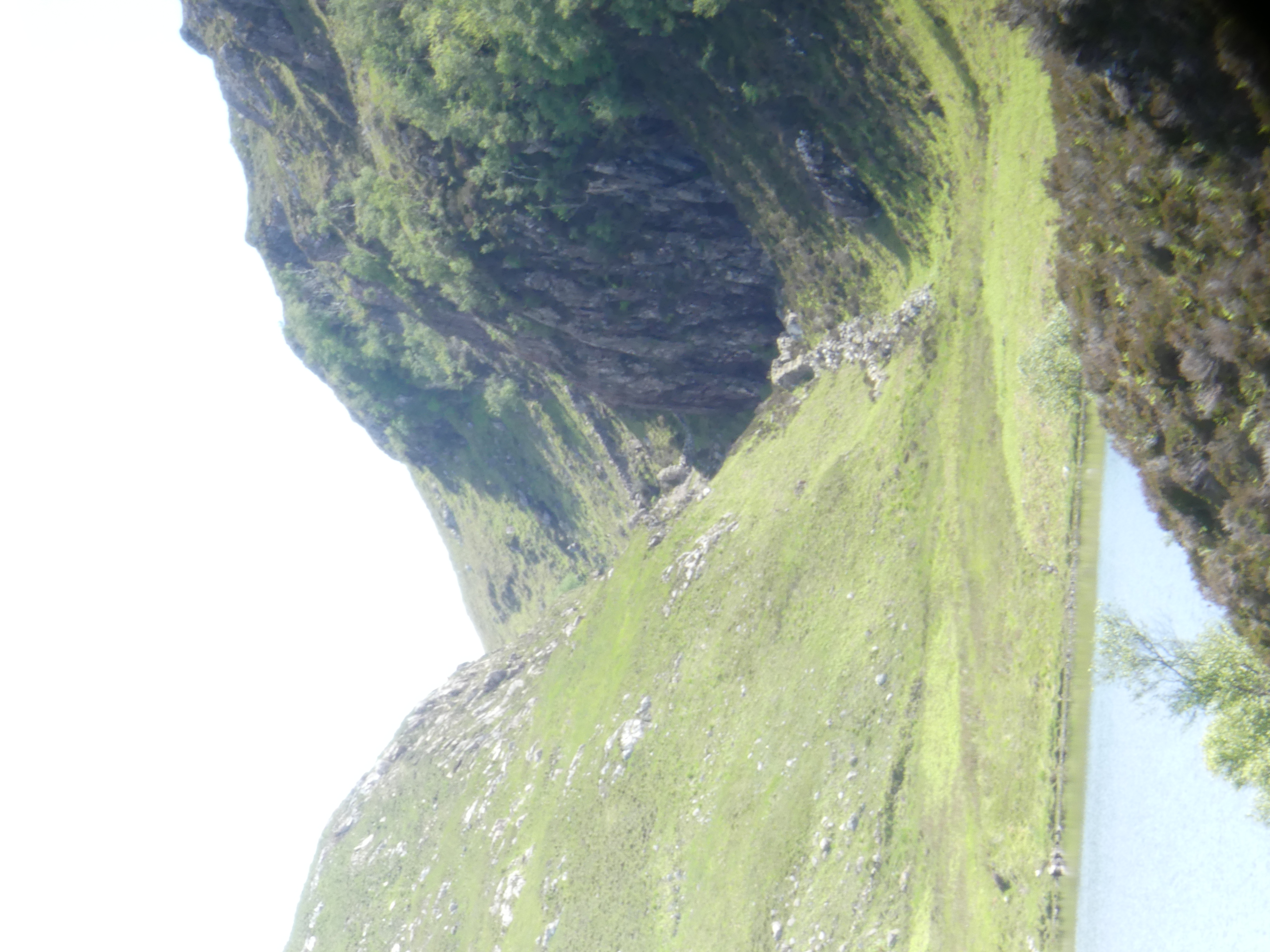
These dramatic features are all aligned in space. How did they form? A paper from 1956 maps them out and links them to a now vanished lake they call ‘Loch Suilven’. Using “an
ex-R.A.F. bubble-sextant in conjunction with a box-sextant“, Alex J. Boyd of Inverkirkaig carefully mapped the fossil beaches left behind by this Loch. From this work it is clear that water levels were once much higher. He inferred that the lake once drained via our dramatic glens, until the modern Inverkirkaig river breached the lake and drained it, separating it out into Fionn Loch, Loch Veyatie and others.
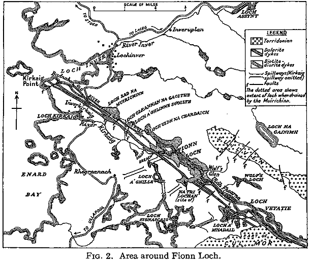
The picture is complicated by ice. This landscape is haunted by the Ice Age and any carving into the ground could have been done by ice as well of water. Glacial melt water channels are features formed by the flow of ice close to glaciers. Water beneath may flow under pressure, or ice may dam rivers, or melt suddenly to create large volumes of water. Under these conditions, channels may be cut by catastrophic flood events.
Tracing the western edge of the area, around Badnaban (place of the women) Boyd reports “rounded boulders” of large size that suggest the water flow was of “torrential character”. High up, the walls of the channel below Cnoc a Mhuilinn have a polished appearance with scalloped shapes. The British Geological Survey interpret these as S-forms and P-forms and call the structure a glacial meltwater channel.

A brief scan of modern literature suggests that there is no consensus about the precise meaning of these features, but for sure they are consistent with a dramatic flooding event scouring out the channels. Ice flow may also have shaped the glens and both mechanisms may have acted at different times. But maybe what was eroded is more important than how it was done.

The sculpture within the block
There’s a quote attributed to the sculptor Michelangelo, to the effect that the sculpture is already there within the block of marble, his job is merely to remove the material surrounding it. For this landscape, this may be literally true. We’ve talked of ice and water cutting into the ground, but maybe the most important features were already physically present within the bed rock, waiting to be revealed.
The cnoc and lochan landscape is an extremely distinctive feature of Lewisian gneiss areas. A similar landscape exists in Connemara on the deformed igneous rocks of Roundstone Bog. The writer Tim Robinson describes this landscape as “frightened”. It’s a largely random distribution of lochs and hills, straight lines appearing where it is cut by geological faults, breaks in the rock that weaken it.
Maarten Krabbendam and Tom Bradwell (of the British Geological Survey) have reviewed the cnoc and lochan terrane in Sutherland and conclude that its distinctive roughness is not a direct product of glacial erosion.
They review similar landscapes in other countries and note that they are a feature of rock type, not of erosion style. They compare the Assynt area with similar terrane in Namibia, where erosion is caused by wind-blown sand rather than ice. They show that the shape of the landscape is mostly controlled by chemical weathering, that weakens solid rock into weak ‘saprolite’. The role of erosion, whether scouring by ice or glacial meltwater, is to remove the saprolite, leaving the harder rock behind.
Chemical erosion is highly sensitive to rock type. The Lewisian Gneiss is cross-cut by vertical sheets of rock called dykes. One particular dyke (400 million years younger than the other Scourie dykes) is rich in olivine, a mineral too chemically delicate to last long at the surface. This dyke easily rots into saprolite, forming deep zones of soft rock. The glacial meltwater channel below Cnoc a Mhuilinn precisely follows this dyke; its location was determined not by the ephemeral flow of ice or water, but by events 1,992,000,000 years ago. Gleann Sgoilte was cut into another dyke and Gleannan na Gaoithe formed along a later shear zone, full of fractured and altered rock.
This pattern is common across the whole of Assynt, wherever Lewisian Gneiss is found. These remarkable glens may be more dramatic than most, thanks to glacial floods, but these were simply picking out the bones of the rock. This landscape was etched rather than scraped.
The post Assynt’s etched landscape first appeared on Metageologist.
]]>The post Looking out for the red rocks first appeared on Metageologist.
]]>Fàire nan Clach Ruadha is one of the countless hills within Assynt’s central wilderness, just another small summit amid the craggy wastes of the Cnoc and Lochan landscape. Once I’d roughly translated it as ‘red stone lookout’, I knew I had to pay a visit. Secretly I was hoping the ‘red rocks’ would be garnet-rich, as is often the case within the Lewisian Gneiss.

On a perfect June day I went in search of the physical realities behind the name. Let’s start with ‘Fàire’. The online resources I’ve used translate this as ‘watch, lookout’, which implies someone once sat on the top of the hill, keeping an eye out for something. This could have been livestock: sheep or cattle. Subsistence farming practices saw animals brought into the interior during the Summer, to make use of the good grazing found here and keep them away from arable crops. Ruins out here are often Shielings, simple buildings built for Summer use only. We are not far here from some and the hill offers good all-round views of the immediate area.
So maybe previous visitors were enjoying themselves, having a relaxed Summer just like me. Tim Robinson translates the Irish phrase for a nostalgic return: “Cuairt an lao ar an athbhuaile” as “the calf’s visit to the old milking place”, a reference to the practice of taking livestock into the hills in Summer. This booleying (to use the Irish terminology) lasted until the 1930s in Ireland and Robinson quotes some idyllic sounding memories of those times.

There is another possibility. Walking inland, this hill is the first to give really distant views of the sea, to raise you above this land’s crinkly corrugations. In the photo above you can see the Achiltibuie peninsula, top left, about 10 km distant. The faint smudges of the Outer Hebrides are clearly visible to the naked eye. Maybe this was a place to look out for ships. There are Norse-inflected names are present near here – Suilven and Inverkirkaig for example. Could a lookout here once have run off in terror, sprinting to give advance warning of a hostile Viking attack? On a glorious June day it seems like an impossible idea. Surely a dot on the horizon would cause joyful anticipation of a returning loved one, home from the sea.
What of the “red rocks”? While the bedrock of Fàire nan Clach Ruadha is made of Lewisian Gneiss, blocks of red Torridonian sandstone are found in great abundance here littering the surface. Some sit proud on the top of the hill, but the most abundant areas are on west-facing slopes.
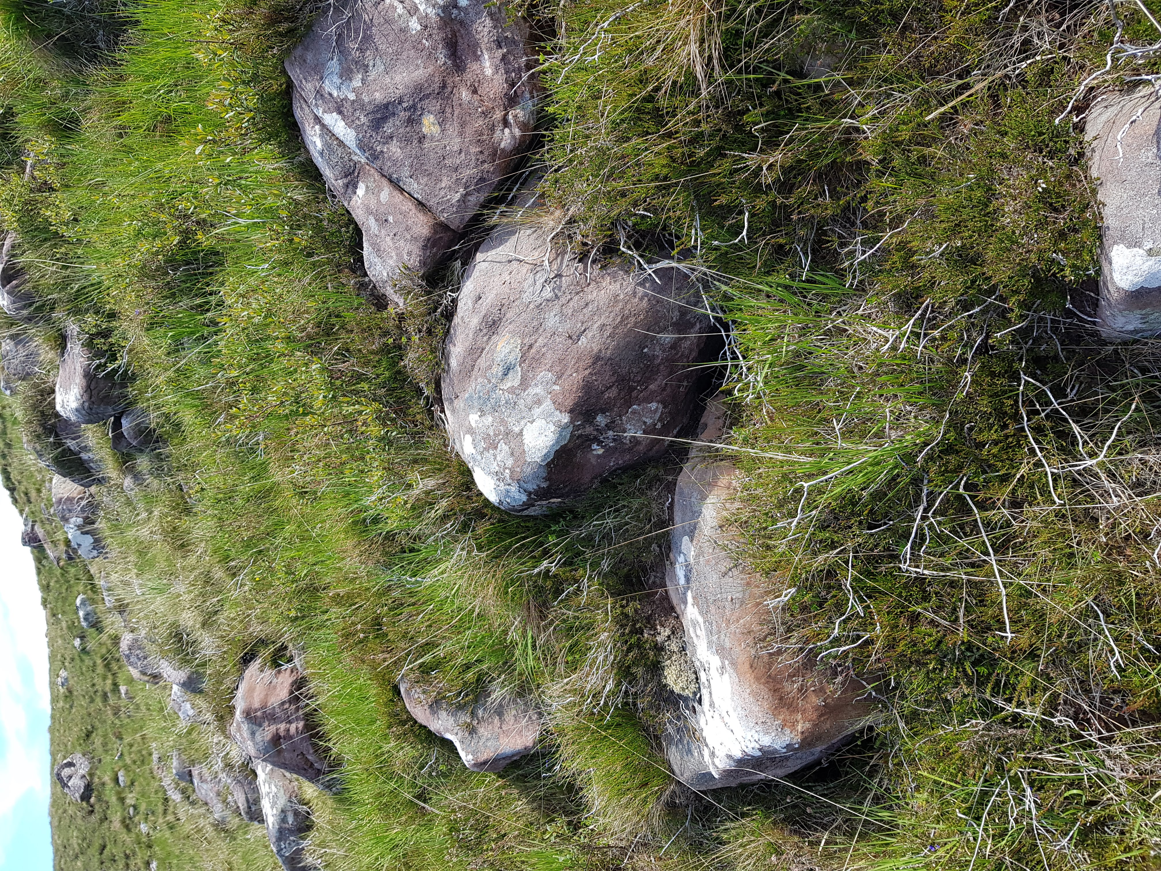
As for much of Assynt, photos taken from here become dominated by the great charismatic peaks of Suilven and Stac Pollaigh. Like being photo-bombed by a celebrity, they immediately become the focus of the image, demanding your attention through sheer charisma. These peaks are also made of Torridonian sandstone, so on Fàire nan Clach Ruadha it feels like they are proud parents, peering down upon their tiny offspring.

Imagine this is how mountains form. The big parent mountain silently urging its offspring to grow up big and strong. Perhaps they are like sharks, the biggest feasting off their siblings in a race to reach adult size. I could be in the midst of a massacre, too slow to register on human timescales.
Of course this is actually how mountains die. Each block was plucked from the side of Suilven by ice and left behind by a now vanished ice sheet. We know this, as people have laboriously mapped the location of these ‘boulder trains’ of Torridonian sandstone, showing a clear link.

Fàire nan Clach Ruadha is within the boulder train coming from Suilven
This academic paper ends with a great acknowledgements section, thanking “the unstinting, though often forced, efforts of a large number of A level Geography students ….helped in the plotting… across this knurled and unyielding landscape, often in the most unhelpful of weather“.
Place names are echoes of how past generations have engaged with a landscape, a reminder that our feet are not the first to tread these rocks. Subsistence farmers on a lazy Summer’s day; somebody anxiously scanning the sea; wet and grumpy teenagers; maybe all have noticed these red rocks before me.
The post Looking out for the red rocks first appeared on Metageologist.
]]>The post Change & Lady Constance first appeared on Metageologist.
]]>I’ve written about an area just south of Lochinver in the west of Scotland. This first post is about two places and why Assynt is so empty.
Hill of the horses
Cnoc nan Each – “Hill of the horses” is both a hill and a place – shown on the OS maps as Cnocnaeach. Fewer than 2 kilometres from the pie-munching tourists of Lochinver it could not be more different.

It’s an attractive spot, a flat-bottomed area underlain by sediment and a contrast to the craggy wastes surrounding it. A range of different ruins show that people lived here for thousands of years. A range of structures (well described here and here) attest to countless generations tending livestock, making a living off the land.
All are gone. The gaelic-speaking people – who lived here and named every hill – were “cleared away” in the Nineteenth Century, put onto ships to Canada, all in the name of ‘improvement’. In economic terms, subsistence agriculture made no sense. To the land-owners, removing the people and filling the land with deer and sheep was a rational decision. The people who were cleared saw this as a tragedy, but nobody cared what they thought. Nobody with power, anyway.
Lady Constance Bay
Just 3 kilometres west of Cnoc Nan Each lies a small bay, marked on some OS maps as ‘Lady Constance Bay’. It’s named – I infer – after Lady Constance Gertrude Sutherland-Leveson-Gower, a member of the British aristocracy. At 18 she married the man who became both the Duke of Westminster and the richest man in Britain.

Constance is unlikely to have spent much time in Lochinver, but as the daughter of the 2nd Duke of Sutherland, she does have a strong connection to the place. Her family were descended – via the Scottish and then British aristocracy – from the head of Clan Sutherland. In Medieval times a clan head was a warrior chief, but by the Nineteenth Century the role was one of absentee landlord. Constance’s grandmother – as owner of most of Sutherland – ordered the clearances there in the name of improvement. The interior of Assynt was depopulated in 1812 on her command.

By 1847 the land was largely empty. In that year, Constance’s father – who liked to spend his money on improvements to his many buildings – planted Culag Woods. This attractive piece of woodland just south of Lochinver is clustered around Cnoc na Doire Daraich or “Hill of the oak thicket”. Lady Constance Bay lies just offshore the woods. Constance was 14 at the time; the bay was surely named in her honour.
New beginnings
Culag woods remains. It’s a community woodland and clearly well loved. The name Lady Constance Bay is not shown on the maps of the wood. I don’t know if the omission is deliberate, but it seems appropriate. Constance’s descendants remain some of the richest people in Britain, but they no longer own Assynt.
Change is slowly coming to Scotland. These two places are still on land owned by absentee billionaires, but following a community buyout a large portion of the interior of Assynt is owned by the Assynt Foundation, to be managed on behalf of local people. A fascinating aspect of the Highlands are the debates over how to move on from the ecological and human impacts of the clearances. Rewilding, wind farms and community buy-outs are all things bringing change to the area, but each raise as many questions as answers. As an outsider, it’s not for me to say how things should change – I’m not even clear whether my holidays there bring benefit or harm – but I’ll be watching with fascination.
The post Change & Lady Constance first appeared on Metageologist.
]]>The post Radioactivity – 50 years that changed the world: part 3 first appeared on Metageologist.
]]>Nuclear fission was discovered as Europe slid towards war and this meant that research became focused on nuclear weapons. After the war, thoughts returned to dreams of generating clean unlimited power. Dwight Eisenhower, the world war 2 general who became US president talked in 1953 of using ‘atoms for peace’. Using nuclear reactors to generate power was a key goal for many countries.
How to design a nuclear power plant
A self-sustaining nuclear reaction produces a lot of energy as heat. This is used to generate steam which turns turbines and generates electricity. This is the goal of any nuclear power plant, but many different types are possible.
Different fuels are used. Uranium and Plutonium are the main fissile elements. Processed Uranium ore can be used, or be enriched to contain more Uranium-235. Mixtures of Uranium and Plutonium may also be used.
Once the fuel is chosen, you need to decide what size of reactor you want, and what output of energy is required. Reactors can generate new fissile elements as well as energy, is this required? Inside the reactor, there needs to be something to extract the heat, usually a liquid that can be pumped through the core of the reactor. A moderator is required, a substance to slow the neutrons so they cause more fission reactions. Sometimes the coolant acts as a moderator.
To control the fission reactions, control rods are used. These are made of a material that absorbs neutrons so that lowering them into a reactor can slow or stop the fission reactions. Safety is important, ensuring that reaction rates are steady and no dangerous highly-radioactive material is released into the environment. Reactors don’t last forever, over time radiation damage weakens them. Modern ones are designed to make it easier to decommission them, removing the most radioactive materials and making them safe.
Devices used in the Manhattan project were based on Enrico Fermi’s first structure, the Chicago Pile-1. These were called a ‘pile’ as they was literally a pile of blocks cooled by air.

Source
The X-10 reactor was used to produce Plutonium. It was a cube of graphite blocks, 7.3m along each side. This was surrounded by 2.1 metre of concrete to absorb radiation, for the safety of the workers. The graphite acted as a moderator, slowing the neutrons. It contained 1260 holes passing through the blocks. Small cylinders (“slugs”) of natural Uranium were covered by Aluminium and pushed into the holes into the core of the reactor. After a few days, during which fission reactions created Plutonium within them, the slugs were pushed out of the other side of the reactor to drop into water for later processing.
Steel rods mixed with Boron were used for controlling the fission reactions. Boron absorbs neutrons, so pushing these rods through channels into the reactor would stop or slow the fission reaction. These horizontal rods were used to control and stop reactions to allow refuelling. For safety, three 2.4m steel rods coated in neutron-absorbing Cadmium were held vertically above the core. They were held in place by a fail-safe mechanism. If electric power was lost they would automatically drop into the core and completely stop the fission reactions.
To avoid damage to the Aluminum-coated fuel slugs the core had to be kept below 200 °C. To control the temperature, air was driven through the core by three fans and then filtered to remove any radioactive particles. The air was taken from outside, meaning that on cold days the reactor could be run at a higher power level as the air cooled it more effectively.
Later designs placed the fissile material within a closed container to allow liquids to be used for cooling. These containers are called ‘reactors’, a name borrowed from chemical engineering.
Generating electricity
The air-cooled pile designs saw the heat as a problem, to be removed from the core and lost as hot air from a chimney. If the goal is to generate electricity from a nuclear reactor then the heat is the useful output. The fluid used to cool the reactor (the ‘coolant’) is passed into a series of pipes called a ‘heat exchanger’. This removes heat from the coolant by heating water into steam. The steam is then used to drive a turbine, spinning a rod within a magnetic field within a generator that produces electricity.
USA developments: first generation of electricity
After the war the Americans built EBR-1, an experimental ‘breeder reactor’. As America started a programme of building many nuclear weapons, there was concern over quantities of Uranium ore available. This breeder reactor generated energy but also converted Uranium into Plutonium and created fissile material (fuel) as well as consuming it. It was cooled by a liquid metal mixture of Sodium and Potassium. This material reacts to water and catches fire in the air, so it has to be handled carefully. The EBR-1 was the first reactor to produce electricity, but initially only enough for 4 light bulbs. It was the first liquid metal cooled fast breeder reactor.
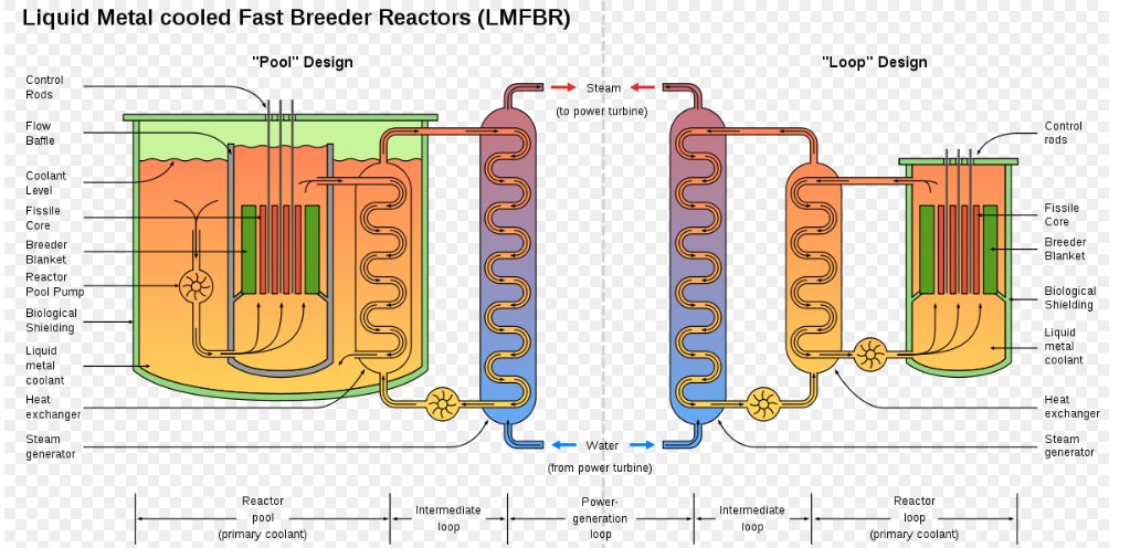
Image source: Wikipedia
This design had various differences compared to the X-10. As a fast breeder type of reactor, a moderator was not required to slow the neutrons. The fuel was placed into 0.6cm diameter rods, which were joined as groups of 60 into hexagonal structures called ‘assemblies’. Overall the core size for EBR-1 was less than 6 litres in volume. Even with all the shielding and heat exchanger added, it was only as large as a single room.
The liquid metal was very effective as a coolant, transferring out large amounts of heat for power generation, running at a temperature of around 300 degrees C. The radioactive material and coolant were all contained within a closed loop meaning the reactor could run constantly for a long time. Vertical control and safety rods could be dropped down into the core.
Once the EBR-1 had proved the general design, much larger scale reactors were built. EBR-2 had a core of 10 times the volume and operated at higher temperatures making it more suitable for electricity generation
British designs for reactors
The British had merged their nuclear weapons programme into the Manhattan Project and so got to share the secret research it produced. The Americans didn’t share their enriched Uranium, however. Wanting to build their own nuclear weapons, the British had to make their own fissile material.
First in 1950/51 they built two nuclear piles for creation of Plutonium for weapons. Then they had to design a reactor that could run on non-enriched Uranium fuel as building their own enrichment facilities would be too expensive. The resulting Magnox reactor design used graphite as a moderator and CO2 for coolant. Four reactors based on this design became active at Calder Hall in 1956. These were the first in the world to provide large amounts of electricity for public use. However, they were also used for Plutonium generation, at least until 1964.
This Magnox design was used in other countries, but because of it’s dual purpose it was not as efficient as later designs that were focused purely on energy generation.
Soviet Union nuclear research
Research into nuclear weapons in the Soviet Union started in 1943 when they noticed that no articles on nuclear physics were being published in the US. They correctly inferred that was because of a secret weapons development programme and so started their own. Soon they were assisted by Klaus Fuchs. A brilliant German scientist, Fuchs was a communist who had fled to the UK to escape political persecution. He was therefore trusted to work on the Manhattan project as he was an enemy of the German government. However his political beliefs meant he saw no problem in sharing secrets from the Manhattan project with the communist USSR.
The first Soviet bomb test was in August 1949, using a Plutonium device based on the American ‘fat man’ design. The Plutonium in the bomb was created in reactors similar to the America X-10 design, using graphite moderators and cooled by air.
As in other countries reactors were soon designed for electricity generation. By 1954 a dual-use reactor had been built and connected to the electricity grid, at Obninsk. This APS-1 Obninsk design used 5% enriched Uranium fuel, was graphite moderated and cooled by water. It was the basis of the RBMK design used for many reactors built in the Soviet Union, including those built at Chernobyl in modern-day Ukraine. Reactors built by the Soviets followed the same principles to those in other countries but had different designs.
Portable reactors
These new reactors built for power generation were large, forming multi-storey buildings. Much smaller nuclear reactors are possible and can be built small enough to move.
The US Navy started research into nuclear reactors in the late 1940s. A nuclear reactor on a large ship can use steam to power turbines for electricity or to drive the propellers directly Aircraft carriers even use the steam directly to power catapults to help planes take off. The reactors are expensive, but allow the ship to stay at sea without refuelling for years. The UK, Soviet and French navies also have nuclear-powered vessels.
Portable reactors need to be small, but powerful enough to provide all a ship’s energy needs. They also need to be simple and easy to maintain – ideally they should not require refuelling for a very long time. Modern portable reactors can be run for decades without refuelling.
Early on, in the 1950s, the US Navy experimented with a Sodium cooled fast reactor (similar to the EBR-1 design) but this didn’t perform well. They switched to a pressurised water reactor design. This uses water as both a moderator and a coolant, but it’s held under pressure, preventing it from boiling even at high temperatures. The pressurised water is kept in a closed container. Pressurised water is circulated through the core and into a heat exchanger which is used to generate steam. A separate loop of piping takes the steam to drive a turbine and power the ship. A condenser is a device that turns the steam back into water before being pumped back into the heat exchanger. The pressure vessel part of the system may be only a few metres in size and still produce enough energy to power a huge ship.
Portable pressurised water reactors have a few differences to larger ones used on land. To ensure a high power output from a small reactor, enriched Uranium is often used. Substances that act as a ‘burnable neutron poison’ are added to the core of the reactor. These absorb neutrons, to help balance the fission reactions. Over time they decay helping to maintain this balance over decades even as the contents of the reactor change as the Uranium fuel is consumed.
The most common use for portable reactors is in submarines. Previously submarines were powered by batteries that were recharged by diesel engines. This recharging had to be done at the surface (to get air) which made the submarines more vulnerable to detection and attack.
Nuclear powered submarines can remain submerged for weeks or even months. As the Cold War between the US and USSR developed, these submarines were built as vehicles to launch nuclear missiles. Both sides feared the other would launch a sudden devastating nuclear attack called a first strike. To prevent this they wanted the ability to retaliate with their own nuclear weapons and so act as a deterrence. Storing the weapons safely in submarines hidden deep under the sea created a ‘balance of terror’ as any country launching a nuclear first strike could be in turn attacked. Some believe this has helped ensure nuclear weapons have never been used since 1945.
The oddest portable nuclear reactor was used actually inside the Greenland Icecap. Camp Century was an American military and scientific research base. It was secretly intended to see if nuclear missiles could be stored for use beneath the ice, but also for other scientific research. People lived and worked in covered trenches dug into the ice. They had plenty of power from a small nuclear reactor installed for that purpose.
As we’ve seen early uses of controlled fission were mostly linked with military goals. They did however prove that nuclear power was a viable source of electricity. Later designs and goals were more focused on civilian uses.
The post Radioactivity – 50 years that changed the world: part 3 first appeared on Metageologist.
]]>The post Radioactivity – 50 years that changed the world: part 2 first appeared on Metageologist.
]]>War and fascism – everything changes
The research described in the previous chapter involved scientists from across Europe, all sharing information and working towards a common goal. Through scientific papers, they shared their ideas equally, allowing people in many countries to contribute. But In 1933 Adolf Hitler took power in Germany. His fascist ideology, based on lies and hatred, blamed Jewish people and other countries for holding back Germany. Between 1933 and 1939 he and other fascist leaders started to discriminate against Jews and it was clear to all that even more terrible things were coming. Many Jewish scientists left Europe for America, to escape persecution. For example, Otto Frisch and Lise Meitner were refugees in Sweden fleeing the Nazi takeover of Austria when they identified nuclear fission.
Another Jewish refugee was Leo Szilard. In 1933 crossing the street in London he had a vision. If slow neutrons could induce nuclear reactions in elements, what if such a reaction created two neutrons? And each of those neutrons in turn made another reaction? 1-2-4-8-16-32-64-128 .. It grows and grows – a nuclear chain reaction. In 1939 (now safe in the USA) he heard of the discovery of fission in Uranium and realised the possibility of creating a fission chain reaction. Nuclear fission, theoretical calculations suggested, released unusually large amounts of energy. A nuclear chain reaction involving fission would suddenly release massive amounts of energy – it would be a bomb of enormous destructive power.
Szilard wasn’t the only person to realise the potential of nuclear fission chain reactions. In the UK – from September 1939 at war with Germany – James Chadwick (the discoverer of the Neutron and student of Rutherford), led serious investigations into the practicalities of making a nuclear bomb. At the same time, the German government started it’s own investigations, led by Werner Heisenberg.
In the USA in 1941, researchers created Plutonium from Uranium. They kept their discovery secret. Theoretical studies suggested that Plutonium, like Uranium, was fissile (could undergo nuclear fission) and could be produced in large quantities from Uranium.
How to make an atomic bomb
By 1941, the basic theory of how to make an atomic bomb was known to many physicists. What’s required is to generate a nuclear chain reaction involving nuclear fission. Two materials were known that did this, Plutonium and Uranium. However only one of the isotopes of Uranium was suitable, Uranium-235. Natural Uranium contained a mix of Uranium-235 and Uranium-238 and nobody knew an easy way to separate them out.
If you somehow managed to get hold of enough of either material, you needed to create a ‘critical mass’ of it. This is where a large enough volume material is tightly packed together such that not too many neutrons escape out, but instead enough hit other fissile atoms and create yet more neutrons and so sustain a chain reaction.
The concept of critical mass can be understood by thinking of a forest fire. If a tree standing alone in a field is hit by lightning and catches fire it releases heat, but this is lost to the atmosphere and soon the fire stops. This is like fission in a small mass of Uranium, a reaction starts but the neutrons don’t hit more fuel and so fission stops. If the first tree is closely surrounded by dead wood and other trees, the heat it produces heats this wood and causes them to start burning – it starts more chemical reactions – and so the fire spreads growing hotter and bigger. This is like a fission reaction starting within a critical mass of Uranium, most neutrons hit more fuel, creating ever more reactions. Nuclear fuel releases much more energy than wood, so things move much more quickly. This would release huge quantities of energy and so create an extraordinary explosion.
Physics is not engineering. Creating enough fissile material and turning it into a working bomb were huge challenges.
Manhattan project
In December 1941, Japan attacked a US naval base called Pearl Harbor and the USA entered the Second World War. Japan and Germany were aligned, so the USA declared war on both Germany and Japan.
Alerted by a letter from Leo Szilard and Einstein, the US government had already started research into nuclear weapons. Knowing of German expertise in nuclear physics, the goal was to create a bomb before Germany did. Now at war, a new US project was created and given the code name of the Manhattan Project. It had enormous resources available to it.
The project called on the best scientists in the world. The best physicists in American universities, like Philip Oppenheimer and the young Richard Feynman were called up in secret. Leo Szilard and Enrico Fermi and others had already fled fascism to reach the USA, and the British project team was merged in as the two countries became allies. In time Niels Bohr was involved, having fled his native Denmark in secret to escape Nazi persecution.
The project brought together different cultures. The many scientists who had fled to the USA from Hungary were called ‘Martians’. This was a joke name as – like aliens from another planet – they spoke an incomprehensible language and were incredibly intelligent. University scientists didn’t always get along with Army engineers. In his memoirs, General Groves – the leader of the Manhattan project – talks of a meeting where scientists gave him their estimate for how much Plutonium was required to make a bomb. Like an engineer, he assumed an estimate was one with maybe 25% or 50% uncertainty. However to physicists a reasonable estimate was one within a factor of ten.
Those on the project were completely focused on one goal, and solving the many technical challenges that faced them. Knowing that there were two types of bomb, based on Uranium-235 or Plutonium and not knowing which would be best, they decided to build both at the same time.
Little Boy, the Uranium weapon
The Manhattan project managed to secure large supplies of Uranium ore, but this contained a mix of Uranium-238 and the more fissile Uranium-235. These different isotopes are chemically identical, making separating them (a process called Uranium enrichment) a huge job. A huge secret site was built called Oak Ridge to focus on Uranium enrichment.
Various different approaches were considered. While chemically identical, U-238 is slightly heavier (because each atom contains more neutrons) so each method finds ways to use the weight difference to separate them.
The first method is to spin the Uranium in centrifuges. These spinning containers separate out the lighter U-235. Attempts by the Manhattan project to build machines failed, but this technique is now the preferred method.
The electromagnetic technique spun Uranium gas through a magnetic field to separate the isotopes. It required huge quantities of copper which was hard to find during wartime. In the end 13 tonnes of silver kept for use as money was used instead. This technique was inefficient, but used known technology and so was used in case the other techniques failed.
The Gaseous diffusion technique relies on the fact that lighter gas diffuses more quickly through a membrane. Huge buildings, four stories high and 0.8km long were built and the technique was very successful. The gas Uranium Hexaflouride was pumped under high pressure into a tube surrounded by a barrier, a membrane that contained thousands of tiny holes. Molecules made of the slightly lighter Uranium-235 (shown as orange dots) could more easily pass through these holes leaving behind gas contained more Uranium-238 (blue dots). This process separated the gas into a enriched stream and a depleted one. The enriched stream would still contain lots of Uranium-238, but it could be passed through into another set of pipes and through another barrier again and again, becoming each time more and more enriched. The depleted steam could be discarded – it was the Uranium-235 that was needed.
(See https://www.atomicheritage.org/history/isotope-separation-methods for some diagrams of this process)
Finally, the thermal diffusion technique placed hot Uranium gas in 15m tall tubes. The lighter Uranium-235 gathered more at the top – this was another effective way of separating out the isotopes by weight.
The three techniques were used in sequence, to create more and more concentrated Uranium-235. Eventually about 50 kilograms of uranium enriched to 89% uranium-235 was delivered to Los Alamos by July 1945 where it was turned into a bomb.

The design was simple, a little like a gun. A long tube contained two pieces of enriched Uranium. Each piece alone was too small to sustain nuclear fission reactions. Conventional explosives fired one piece down the tube into the other. This joined mass was big enough to become critical and create a nuclear fission chain reaction and so an explosion. The bomb had the codename “little boy”.
Fat man – Plutonium weapon
Despite being only discovered the year before, Plutonium was seen as another potential fuel for a bomb. Plutonium could be produced from un-enriched Uranium, by generating a controlled nuclear fission reaction. Nuclear fission reactions would produce neutrons, slowed by graphite blocks. The material that slows the neutrons is called the moderator, as it moderates (slows) the speed of the neutrons. Some of these neutrons sustain a steady rate of reactions, others turn Uranium into Plutonium. The rate of reaction was controlled by adding rods that absorbed neutrons to slow or even stop the reactions. The designs ensured there was no ever-increasing chain reaction as was wanted in a bomb, just a steady rate. The reactions produced heat, but the real purpose was creating Plutonium. Importantly, the Uranium fuel could be unprocessed ore – there was no need to enrich the Uranium-235 first.
Enrico Fermi, piled up Uranium oxide and graphite blocks in a squash court in a sports ground at Chicago University and so in 1942 created the first (man-made) self-sustaining nuclear reaction in Chicago Pile-1, the ancestor of all nuclear reactors. Soon a small secret town called Hanford was built to house a number of bigger nuclear reactors all dedicated to producing Plutonium. Once Plutonium had been produced, it could be chemically separated from the Uranium material.
The design of the weapons was done at a site called Los Alamos. This required intense work from many of the world’s best physicists. To know if the bomb would work, they had to understand how it would work. To start with they calculated the energy released by a single fission reaction. This required knowledge of the exact mass of the material before and after, to calculate the missing mass converted to energy according to the Einstein equation.
That was the easy part. To create a sustained chain reaction, a large amount of fissile material needs to be suddenly pressed together to make a critical mass. A problem with the Plutonium was that it contained a mix of different isotopes, meaning the fission reactions acted in a different way. The material produced within the reactors contained more plutonium-240 (a very reactive isotope) than expected. This would start fission reactions much sooner than the plutonium-239. If a gun design was used, like in Little Boy, then the plutonium-240 would fission early and push the Plutonium apart before most of the material – the plutonium-239 – could fission. This would cause the bomb to fail to explode properly.
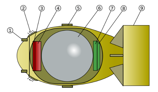
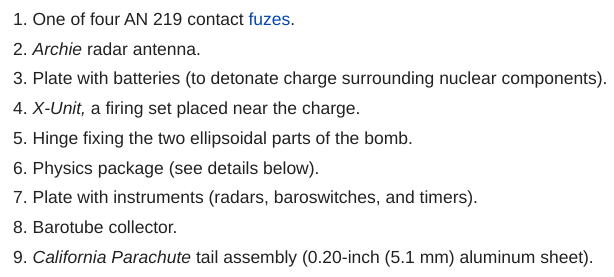
So a different and more complicated bomb design was required, one that involved taking a sphere of Plutonium and surrounding it with conventional explosives. The physicists had to write equations to model the behaviour of the Plutonium pressed together by explosives, then track the fission reactions as a critical mass was formed. Imagine trying to understand in detail what happens in the heart of a bomb, and then add on the complexity of understanding the fission reactions. Many equations and long difficult calculations were required and because Plutonium behaves different from Uranium, all the calculations were different from those required for the Uranium bomb design. The concept was simple but the design was complicated. The explosives were made with a complicated three-dimensional shapes to focus the shock wave through them and down onto the ball of Plutonium. The yellow detonator, started different conventional explosions with the outer layer of explosives. The curved shape at the based helped join the different shock waves into a single spherical wave that was then increased by two further layers of conventional explosives. This then compressed three different layers, of Aluminium, plastic and then Uranium, each with a different purpose.

Inside all this, the red Plutonium contained a polonium-beryllium initiator, a device that when compressed provided a good source of neutrons to initiate the chain reaction. The size and round shape of the bomb compared to ‘little boy’ led to it being called ‘fat man’.
They ran tests of the explosives (without any Plutonium) and used X-rays to see what happened inside, but still any big mistake in these calculations and the bomb wouldn’t work.
German efforts
Scientists who before the war had cooperated now found themselves on opposite sides of a vicious war. Non-Jewish German scientists like Werner Heisenberg might not be supporters of Hitler’s fascism, but most chose to stay and support their country as it fought a war.
Heisenberg was asked to lead efforts in Germany finding uses for nuclear fission. He understood as well as anyone the possibility of making a bomb, but focused mostly on the potential for energy generation, rather than weapons. Some people speculate that he did this as he didn’t want to give Hitler such a powerful weapon, but no-one knows for sure.
The Manhattan Project was started precisely to get a bomb before Germany, but nobody knew that Heisenberg would fail to deliver. To slow down any German efforts, the UK army, working with locals, attacked a site in Norway that was a source of heavy water, useful for nuclear research. In 1944 Heisenberg gave a talk in Switzerland, a neutral country. A US agent was sent with instructions to kill him if the talk suggested that Germany was close to having a bomb, but of course there was no need.
Testing and use in war
By 1945 the Manhattan project had achieved so many things. It had produced enough Uranium-235 for a single bomb and larger quantities of Plutonium. We’ve seen how complicated the calculations required for bomb design were – what was needed now was a test, to see if nuclear weapons actually worked.
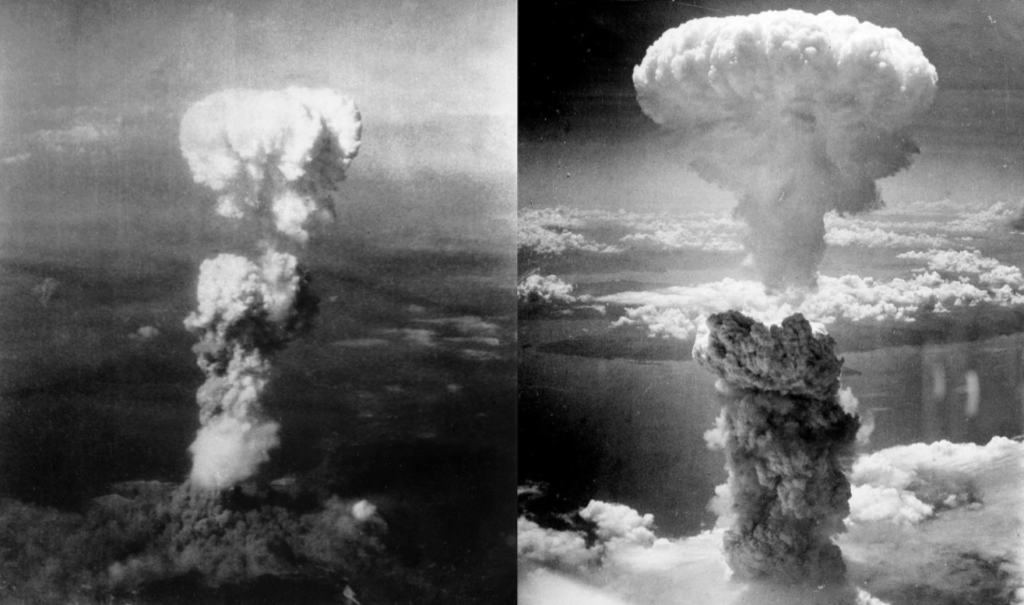
A version of the fat man weapon was built and a site deep in the desert chosen. At 05:29 on the 16th July the device was exploded at the Trinity Test site. A huge flash of light lit up the desert, with colour changing from yellow, red to purple. A ball of fire slowly rose leaving behind a column of smoke, forming a characteristic mushroom shape. After about 40 seconds the blast wave reached the observers. Enrico Fermi dropped a series of pieces of paper and saw how far they were blown by the wind. He had already made a rough calculation and from the distance the paper was blown he estimated the size of the explosion to be the same as that created by exploding 10,000 tonnes of TNT.
The bomb contained 6.2kg of Plutonium of which 1kg was transformed by the fission reactions. Of that mass, about a gram was converted directly into energy. Enough energy to turn the desert sand beneath into glass.
The initial reaction of the scientists watching the test was joy at their success, but slowly they became solemn as they realised how terrifying a weapon they’d created. The blast wave spread outwards and was heard over a hundred kilometres away. A fake cover story was invented to explain it as the new bomb was still secret. The political implications spread around the world.
Nazi Germany had been defeated a few months earlier, but the war against Japan continued. The Japanese armed forces had been mostly defeated outside of Japan but refused to surrender. Faced with the prospect of having to invade Japan the US Army estimated that this would mean half a million US soldiers and 5 million Japanese people would be killed. The American president turned to his new atomic weapons as an alternative. On 6 August 1945 the Little Boy Uranium-235 weapon was dropped on the Japanese city of Hiroshima. Three days later a Plutonium fat man weapon was exploded over Nagasaki and six days after that, Japan surrendered and the war was over. Many of the scientists who worked on the Manhattan project argued the bombs should not have been used and were appalled that 10,000s of civilians had been killed by what they had built. The alternative argument is that they ended the war early and so saved more lives that way. Probably people will never agree which interpretation is correct.
Aftermath and impact on science and beyond
Nuclear physics moved in only a few years from experiments on tables in laboratories to a huge engineering project. Theoretical physicists would produce equations that within days were being used to design new machines and industrial processes.
Some of those who worked on the Manhattan project moved back into basic research. Having demonstrated it’s practical value, physicists had little difficulty finding the funding for building the bigger and bigger machines required to explore deeper inside the atom. The search began to find out what smaller particles neutrons and protons were built up from.
Some others stayed in weapons research. The process of fusing small atoms together – nuclear fusion – produces even more energy than fission and within 10 years a fusion weapon – the hydrogen bomb – had been made and tested. Others focused on more peaceful uses of nuclear fission. This included fields like medicine but many thought of the heat produced by the Manhattan reactors and saw it as a source of cheap energy.
The post Radioactivity – 50 years that changed the world: part 2 first appeared on Metageologist.
]]>The post Radioactivity – 50 years that changed the world: part 1 first appeared on Metageologist.
]]>Around 1.7 billion years ago, a thick layer of rock rich in the element Uranium began to heat up. The tiny blobs of matter in the centre of the Uranium atoms split into two new atoms, releasing energy and radiation. Special conditions caused more and more atoms to split and produce heat until the water in the rock layer boiled away, making things calm again. This rock layer is now in Gabon, Africa and is the only known example of a natural nuclear reactor.
In the 19th Century, physicists still had no idea such things were possible. Geologists studying thick layers of sediment argued the world must be hundreds of millions old, as these layers formed so slowly on the modern earth. Previously people in Europe had regarded the Christian Bible as evidence that the earth was only thousands of years old. Physicist Lord Kelvin calculated that even if the earth started out extremely hot, that it would be become cold after only a few million years. He argued that the existence of volcanoes today suggested the earth could not be very old and so the geologists were wrong. His arguments were based on the fact that nobody knew of a mechanism that could heat the earth from within. Scientists had discovered many elements (Uranium was identified in 1789) and had a good understanding of chemistry, but believed atoms to be fundamental unbreakable units.
Discovery of radioactivity
The first hint that there was something more to be discovered came in 1896 when French scientist Henri Becquerel was experimenting with some Uranium compounds. He was investigating the effects of exposing them to sunlight, but the discovery came when he left them in a closed drawer with some photographic plates. When he took them out, he discovered the plates were fogged.
This discovery led to many more experiments of the strange properties of Uranium. The first step was to introduce a magnet, affecting the space between the Uranium and the photographic plates. This showed that whatever was coming out from the Uranium, it came in three different types. The first type was pushed away by the magnet, the second pulled towards it and the third not affected by the magnet at all. By 1897, New Zealand scientist Ernest Rutherford had named these types Alpha, Beta & Gamma after the first 3 letters of the Greek alphabet. He showed that they had different properties. Alpha particles were positively charged and did not travel far – a few centimetres of air could stop them. Beta particles are negatively charged and could be stopped by a millimetre of Aluminium. Gamma particles were unaffected by a magnet and could pass through solid materials – it took a few centimetres of lead to stop them.
French-Polish scientist Marie Curie invented the term ‘radioactivity’ to describe these mysterious effects. Working with her husband Pierre she started to study the chemistry of the mineral called ‘pitchblende’ from which Uranium was extracted.
She had noticed that pitchblende was actually more radioactive than purified Uranium. She inferred that pitchblende must therefore contain another unknown element even more radioactive than Uranium. Pierre and Marie dissolved large amounts of pitchblende in acid and using standard chemical techniques, by 1898 had extracted a black powder made up of a new element, 330 times more radioactive than Uranium. They called it Polonium, after the latin for Poland, her native country.
Being thorough, they also studied the liquid left after they had extracted the Uranium and Polonium from the Pitchblende. It was still radioactive! They realised the liquid contained another unknown element, but in really small quantities. They had to dissolve a lot of pitchblende to get the Polonium, but it was too expensive to get the amount they needed.
They contacted a factory who extracted Uranium from pitchblende. The factory was piling up what was left once the Uranium was extracted, worthless to them but exactly what the Curies needed. In simple conditions – no more than a shed – they processed many 20kg batches of this waste, working on a much bigger scale. The work to extract the new element was complex and hard, but by 1902 they had enough to prove it was another new element, called Radium.
For her work on radioactivity, Marie Curie became the first person who has won two Nobel Prizes in different subjects, one in Physics, the other in Chemistry. Her work to isolate these new highly radioactive elements was vital for future research. Many of the future experiments we’ll describe used small samples of Radium to provide a strong source of radiation.
Exploring radioactivity
Radioactivity could not be explained by existing models of the atom, so new ones were needed. The old ideas of the atom as an unbreakable unit had to be discarded, as radioactivity involved breaking atoms into pieces. Physicists started to try and understand what things are within the atom.
In 1897 English physicist J.J. Thomson was experimenting with putting high voltage across two metal plates in a vacuum tube. He saw a stream of particles passing between the plates and was able to show they were negatively charged and extremely light. He called these particles electrons – and showed they must have come from inside atoms.
Normal atoms are electrically neutral, so he speculated that the inside of an atom was a mixture of negatively charged electrons and unknown positively charged parts. He saw them as all mixed together, like pieces of fruit within a cake. This was called the ‘plum-pudding’ model of the atom. In 1899 Becquerel speculated correctly that the beta particles given off by radioactivity might be electrons travelling at high speed.
By 1901 the Curies, using material that had extracted themselves, performed important studies of the heat energy given off by radioactive elements. They showed that the heating never stopped, producing large amounts of heat over time. This was not explainable by existing physics. The ‘laws of thermodynamics’ state that energy can never be created or destroyed, just transferred. Heating a room by burning coal turns chemical energy into heat energy, but eventually the coal is used up and it stops. Radioactive heating was different and could not be explained at the time.
In 1903 Ernest Rutherford (a student of J.J. Thomson) revisited the arguments made by Lord Kelvin against a very ancient earth and showed that the geologists were correct. Slow radioactive heating from elements like Uranium over billions of years is what keeps the earth hot inside
What is radioactivity and what are its effects?
Most elements are very stable, but radioactive ones are not. Completely randomly a ‘parent’ atom breaks apart, turning into a different lighter ‘daughter’ element. The process of radioactive decay is messy, producing energy and three different types of particles which are fired out at speed. These are the three types of radiation, alpha, beta and gamma.
Radioactivity doesn’t break the laws of thermodynamics as there is a conversion of some matter into energy. Eventually all of a radioactive element decays and it turns into some other element. An element’s ‘half-life’ is the time it takes for half of it to decay. This can vary from seconds – for some very radioactive elements – to billions of years for Uranium and Thorium.
The radiation emitted travels until it hits something and stops, transferring its energy into what it hits. This can cause damage, particularly to organic molecules like those that you and I are made of. High levels of radiation damage tissues in a variety of ways and cause ‘radiation sickness’ that can be extremely dangerous. Even low levels of radiation can damage DNA and make cancers more likely. Beta and gamma particles are the lightest and cause the least damage, but travel the furthest. If radioactive elements touch or even enter the body – through the lungs or stomach – it’s the most dangerous as the body directly receives Alpha radiation which causes the most damage.
Radioactive elements are today tightly controlled, but that wasn’t always the case.
Radioactivity: discovery of uses and dangers
When they were first discovered, people used radioactive elements in many ways. Adding Uranium to glass gives it a beautiful green colour that was popular. Before it was properly understood, people claimed radioactivity was healthy and they sold radioactive waters as cures to various ailments. Radium is luminescent, meaning it glows in the dark, so following its discovery people found uses for it. Starting from 1917 was used as paint on watches in the USA. Slowly it was realised that the workers handling the radium were suffering a whole range of serious health issues. It took decades for the mostly female workers – called ‘the radium girls’ – to get compensation from their employer for the harm done to them.
The first known victim of radioactivity was Marie Curie. She and Pierre suffered from radiation sickness while processing pitchblende. They felt unwell and had burns on their hands from handling the highly radioactive material. Marie Curie herself died in 1934 from exposure to radiation. Her working papers – even her body – became highly radioactive and are now stored in a lead box for safety.
Understanding atoms
Scientists continued to study radioactivity. Small samples of radioactive elements were used as sources of radioactivity meaning hugely important experiments could be done on a table-top. In 1909 Ernest Rutherford placed a radioactive source of alpha particles in a glass tube from which air had been removed. Over time the vacuum filled with a gas formed from the alpha particles. He was able to show that this gas was the element Helium.
It was clear that radioactivity included pieces of atoms. Beta particles were negatively charged electrons and alpha particles the positively charged part of Helium atoms. In 1909 Ernest Rutherford designed an experiment to fire alpha particles at a thin piece of gold foil, using a detector to see what happened to them. Placing the detector behind the gold foil showed that most alpha particles passed straight through, as expected. Placing the detector in front of the foil brought a surprise – a few alpha particles ‘bounced off’ the gold foil. This experiment showed the structure of atoms. They are mostly empty space, which is why most alpha particles pass straight through. The ones that bounce back must have hit the main mass of an atom and this part of the atom must be small, explaining why only a few hit it. This small mass in the middle is called the nucleus of the atom and things related to the nucleus are called nuclear.
By 1913 Rutherford and Niels Bohr, a Danish theoretical physicist had devised the Rutherford–Bohr model of the atom. This model was a combination of experimental data and a part of theoretical physics called quantum mechanics.
This combination of theory and practice continued, as scientists searched for the different parts of the atom. In 1920 the Proton was named. This is a fundamental particle within the atom that has a positive charge and a large mass. In 1932 the Neutron was named, a particle within the atom with neutral charge and large mass.
What’s inside an atom?
Atoms are a little like the solar system. At the centre is a massive object, the positively charged nucleus of the atom. Circling this massive object – like planets orbiting the sun – are the much smaller negatively charged electrons. Electrons are more familiar to us. Atoms sharing electrons are what form the chemical bonds that join atoms into compounds. Electricity is the flow of electrons between atoms.
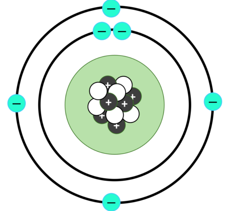
The nucleus is a mixture of neutrons and protons strongly joined together. The number of protons in an atom is the atomic number, as shown on a periodic table. It determines which element it is. To be electrically neutral, the number of protons is matched by the same number of orbiting electrons, which determines its chemical properties.
A hydrogen atom is a single proton orbited by a single electron. But to be stable, larger nuclei need to include Neutrons, joined tightly with the Protons. The nucleus of Helium typically contains two protons and two neutrons. Atoms can contain different numbers of neutrons and still be the same element, they are known as different isotopes. Adding or removing Neutrons doesn’t affect the electrons so it’s the same element with the same chemistry. For example Helium is typically Helium-4 (2 protons and 2 neutrons make 4), but Helium-3 can also be found. It has 2 protons and only 1 neutron.
Radioactivity is created when a nucleus spontaneously breaks up into smaller pieces. In natural radioactive decay, large fragments become new atomic nuclei (with fewer protons and neutrons) and smaller parts make up the Alpha, beta and gamma types of radiation. As part of the breakdown of the atom, some mass is converted into energy, which is why the particles all move extremely fast.
As an example, the natural radioactive decay of Uranium-238 creates alpha radiation and conversion of the atom in thorium-234. It’s also possible for Uranium atoms to split in two, to create two new atoms both much lighter than Uranium. Instead of a small piece coming out of the nucleus (like for natural radioactivity), the nucleus splits into two large pieces and some smaller ones. This process is called nuclear fission.
Discovery of nuclear fission
Scientists continued to find new sources of radioactivity and devise new experiments. Around 1934, Enrico Fermi, an Italian scientist, performed a series of experiments with a mixture of radon and beryllium that was a source of neutrons. He discovered that by firing neutrons at 22 different elements he could make them radioactive. The neutrons were added to the nucleus, causing it to become unstable and so break apart.
Running the experiments, they noticed that the same experimental apparatus transformed elements more quickly when placed on a wooden table than if sat on a stone surface. It seemed the material beneath was having some effect on the neutrons passing between the source and the target – perhaps some were passing through the table and bouncing back up to the target.. Speculating that the speed of the neutrons was affected by the material they passed through, they put paraffin wax directly between the source of neutrons and the target. The effect was dramatic – the neutrons were slowed down by the paraffin and became much more effective at changing the target material. To change an atomic nucleus, a neutron needs to come close and become joined to it. If it is travelling fast, it is less likely to do so. Think of meteorites speeding close to planets – if they are travelling fast then they speed right past even if they get close. If humans send a probe to a planet, they usually slow it down as it gets close to ensure it is ‘captured’ by the planet by going into orbit or landing on the surface. Slowing neutrons has a similar effect, they are more likely to be captured by an atomic nucleus than if they are moving faster.
In 1938 German scientists firing neutrons at Uranium found some odd results. They had bombarded Uranium with neutrons and observed the element Barium produced as a result. This was odd as Barium had 40% less mass than Uranium. Normal radioactive decay never causes such a dramatic drop in mass from parent to daughter element. Lise Meitner working with her nephew Otto Frisch, interpreted this as an example of a nucleus splitting into two, something she called nuclear fission. The neutrons hadn’t just caused the Uranium nucleus to become unstable, but had made it split into two large pieces: Barium and the gas Krypton. This was something new.
Mass into energy
The mass of a nucleus is always less than the total mass of the individual neutrons and protons that it formed from. For example, an alpha particle is two protons and two neutrons joined together, but it’s mass is 0.8% less than the mass of those four particles measured as individual protons and neutrons. The difference is because of something called nuclear binding energy. This energy is required to keep the nucleus together, as the protons want to move apart due to their electric charge. Things are strange in the nucleus, it’s a place where energy and mass are interchangeable, as shown by the Einstein equation:
E = mc2
Where E = energy, m = mass and c is the speed of light.
The speed of light is very fast – meaning only a tiny amount of mass converts to a huge amount of energy. If a nucleus changes, like in radioactive decay or fission, there will be a change in the required nuclear binding energy and so in the mass of the particles before and after. If the total mass afterwards is smaller, then the difference will be converted into energy.
The amount of energy released varies a lot. Think of the amount of heat released by burning wood or coal in a fire, a typical chemical reaction. Using SI units, the amount of energy released per amount of material changed is around 400 kJ/mol. That’s enough to heat a room on a cold day.
For normal radioactive decay, heat is released, as Marie Curie first described. The total energy released is about 10,000,000 kJ/mol. This is a huge amount more, but remember this is the amount released after all the radioactive element has decayed. Coal releases its chemical energy quickly but this energy release from radioactive decay may be spread out over billions of years. This is one of the (many) reasons we don’t heat our rooms by simply putting radioactive elements in it.
For a fission reaction compared to radioactivity, about a hundred times more energy is released, measured in billions of kJ/mol. Unlike radioactivity, we can control the speed of fission reactions. The rest of this magazine will describe the many ways people have sought to harness the incredible potential of this source of energy.
From theory to practice
Natural radioactivity is slow and can’t be controlled. The Uranium deposit in Gabon created heat because neutrons slowed by water created nuclear fission reactions, but this was an unusual occurrence. However the experiments in the 1930s showed that it was possible to artificially cause nuclear reactions. Of course people speculated how this could be a new source of energy, now reactions could be controlled. Very few imagined how quickly and dramatically war would turn these theoretical discussions into real and practical matters of life and death.
The post Radioactivity – 50 years that changed the world: part 1 first appeared on Metageologist.
]]>The post What drives plate tectonics? first appeared on Metageologist.
]]>The earth is affected by gravitational forces from the sun and the moon. These move huge volumes of water every day, causing the oceanic tides. They even cause small (but measurable) changes to the shape of the earth, the surface moving up and down by a few centimetres. As the earth and moon rotate quickly, these movements are quick and elastic, meaning the earth returns back to its original shape. It’s like a tall building swaying in the wind or during an earthquake. Elastic changes are where atoms move apart from each other, but the bonds within the material are not broken. Plate tectonics is like the entire building is moving, a permanent change caused by rocks slowly flowing or breaking.
Forces caused by plates
There are broadly two sets of forces that move the earth’s plates: those created by the plates themselves and those involving interactions with the mantle below.
Plate tectonics requires plates to be rigid and deform at the edges, they are strong enough that a force acting on one part of the plate pushes the entire plate. There are two sets of forces created at the edge of oceanic plates, one where they are created and another when they destroyed.
diagram of ridge push http://www.columbia.edu/~vjd1/driving_forces_basic.htm>
Ridge push is a force created at mid-ocean ridges where the flowing mantle (asthenosphere) rises up towards the surface. This occurs because the reduction in pressure allows melting and reduces the density of the material. As oceanic lithosphere (oceanic crust plus the stiff mantle material fixed to it) moves away from the ridge it cools and sinks as its density increases. This causes a slope and gravity acting on the higher ridge causes a horizontal force that pushes the entire plate horizontally. Some scientists calculate that a lot of the force pushing India into the Eurasian plate (creating the Himalayas) comes from the many ridges in the Indian ocean pushing on the plate.
Slab pull is a force associated with subducting oceanic lithosphere. Old cold oceanic lithosphere subducts because it’s denser than the surrounding mantle, therefore this negative buoyancy causes a force pulling on the edge of the plate. As it sinks it heats up, but also it is put under increasing pressure from the rock above it. This starts to drive metamorphic reactions that change minerals in the rock into different ones, more stable under the new conditions. Generally minerals with more compact, denser mineral lattices are stable and so the density of the rock is increased. The first transformation is called eclogitisation, but some oceanic plates reach the middle and lower mantle and so will undergo multiple transformations.
We get a sense of the strength of this force by considering how these transformed subducted rocks – eclogites – reach the surface again. Eventually any subduction zone runs out of oceanic lithosphere, and the thin leading edge of the attached continent is pulled into the subduction zone where it is transformed at depth into eclogite. Contintental crust is much more buoyant and thicker than oceanic and resists subduction, meaning that subduction eventually stops. The deeper subducted oceanic lithosphere is pulling the other way and eventually it breaks in two. Once the force of the sinking oceanic lithosphere is removed, the buried edge of the continent, together with a stub of oceanic lithosphere, is quickly pulled back to the surface – bobbing back up like a balloon under-water.
The flowing mantle
Slab pull and ridge push are together one set of forces that act once plates are moving. In addition forces will push onto plates from the convecting mantle below.
Convection is a physical property of bodies that can flow and are hotter below than above. Hotter material is less dense than cool, so rises up and is replaced by cooler sinking material. You can see this sometimes in cooling soup, where patterns of flow affect the surface.
Within the earth, sinking oceanic slabs will drag mantle material down with it and so become the downward flow part of convection. Similarly mid-ocean ridges are places where heat is released from the mantle and may correspond to an upward flow. However evidence from volcanic islands such as Hawaii suggests that mantle flow is more complicated than that. Most earth scientists believe in the existence of mantle plumes, long-lived flows of hotter mantle up towards the surface. The track of a mantle plume across the Pacific explains the pattern of the Hawaiian Islands. A mantle plume that caused volcanic activity in Greenland and the British Isles when the North Atlantic Ocean opened 60 million years ago is still active under Iceland, making that portion of the mid-Atlantic ridge above the surface.
These plumes appear to be unaffected by the passage of plates above them, and some scientists regard them as being fixed in location within the earth, being deep-seated structures.
Seeing the effects of mantle convection on the surface movement of the plates is difficult. There are places on the earth, such as southern Africa which are much higher than we would expect. It seems that this is an area of upward mantle flow and this force is raising up the African continent, forming the high plateau that covers much of South Africa.
Supercontinents
Plate tectonic movements in the past show patterns where continents joined together into supercontinents, only to split apart again. The most famous supercontinent is called Pangea and it existed 270-200 million years ago. It contained all modern continents joined together. It’s breakup led to the creation of the continent shapes we are familiar with today. The Atlantic split apart the Americas from Europe and Africa. India, Antarctica and Australia were split apart by the creation of the Indian ocean. Also the Tethys ocean closed sending India colliding into Eurasia.
Map of Pangea showing modern plate boundaries on it. Like https://www.worldatlas.com/articles/what-is-pangea.html. There are some wonderful examples on http://www.earthdynamics.org/earthhistory/Learn%20About%20Palaeogeography.html
Pangea formed late in the earth’s history. Before it the continents were separated from each other, but by different oceans that are now totally lost (the oceanic plates are now down in the mantle somewhere). We can trace the lines of the lost oceans by the traces of the collision when they formed or by patterns of fossils. Also slices of them called ophiolites may be found, lost within the centre of continents.
The line marking an ancient ocean can be found in countries around the North Atlantic. Called Iapetus, the join where it once was is often close to the modern Atlantic. By painstakingly tracing traces of ancient oceans, combined with computer modelling, scientists have discovered other supercontinents older than Pangea. These are from times so far back that the shapes and names of continents are unfamiliar, but the processes are the same. Up to 13 supercontinents have been identified and named, going right back to earth’s earliest rocks. They appear to form and break-up at intervals of a few hundreds of millions of years.
Whether or not the earth’s continents are all joined together or split into different parts affects many things. Continental shelves are great places for life, creating large areas of shallow water. If all continents are joined together, there is less continental shelf for creatures to live on. Cycles of supercontinent creation and break-up have been linked to changes in climate, patterns of the evolution of life, creation of continental crust, formation of ore deposits and many other things.
Breaking up continents is not easy as continental lithosphere is stable and strong. The break-up of supercontinents seems to be linked to mantle plumes. A plume rising above a continent will heat it and push it up. Mantle flow away from the plume will start pulling the plate apart and the heat and volcanic activity make it easier to break. Some theories suggest that a supercontinent insulates the mantle below and eventually causes a hot plume to rise beneath it. This would explain why supercontinents form and are destroyed again and again in earth history.
Computer modelling goes “beyond plate tectonics”
The only real way to understand the complicated patterns of flow in the earth is by using computer modelling. Only computers than track the different types of force and the fact that this is all happening on a spherical earth. They can be used to try and bring together the theory and the real-life observations to reproduce patterns of plate tectonics over the history of the earth.
In building the models, scientists can use a lot of equations that describe the physics of how hot rocks flow – how they deform and how convection works. They also ensure that all the forces balance, that the earth remains the same size and that the surface plates are not spinning around the world.
Into this theoretical model they add all the observations that led scientists to produce the theory of plate tectonics in the first place. Geological evidence of continental drift shows when continents were joined or moved apart. Magnetic stripes show how ocean basins opened, seismic tomography can see ancient subducted plates and help calculate where subduction zones were in the past. Techniques like palaeomagnetism show what latitudes rocks were at in the past.
Computer models now include all of this information and link it together in a consistent way. These models can describe both the movements of tectonic plates and patterns of ancient mantle plumes. Some say this is moving beyond plate tectonics and into a deeper understanding of how the entire earth works, not just the surface.
One example of the power of these models comes from studies of the distribution of diamonds at the surface of the earth. Diamonds form deep within the mantle, potentially over much of the earth, but they only come to the surface in particular places. Diamonds reach the surface within special types of volcanic eruptions called kimberlites. These are only found in very old parts of continents in Africa, North America, Australia and Asia. Deep under old continents, there is a thick and stable layer of cold and strong mantle attached to the crust. Kimberlites form when this old material is heated and molten rock rich in carbon dioxide is formed. This super-light material quickly shoots to the surface containing fragments of mantle rock within it, sometimes with diamonds. Computer modelling of past plate movements suggested that kimberlite eruptions occur when old continental lithosphere is heated by mantle plumes rising from below. Furthermore, mantle plumes tend to rise from the edges of mysterious structures at the core-mantle boundary called LLSVPs.
<<example of results of this modelling. first diagram in https://www.pnas.org/content/111/24/8735/tab-figures-data
This particular research is fairly recent and like most new studies is not accepted by all scientists. But it illustrates the power of these computer models. If it correctly explains where and when kimberlite eruptions occur, it could help mining companies find new kimberlites and so find new diamond mines.
These computer models are never complete. Scientists using computer modelling of complex systems like climate or the earth’s interior joke that all models are wrong, but the best ones are useful. They understand that new research will improve on existing models, but ones today can increase our understanding and suggest new areas of research.
First publication by Xiaoduo Media in Front Vision. Front Vision is a Chinese online science magazine for children. My original English text produced with permission.
The post What drives plate tectonics? first appeared on Metageologist.
]]>The post Plate tectonics first appeared on Metageologist.
]]>Plate tectonics is one of the most successful scientific theories of the Twentieth Century. It explains the major structures of earth’s surface and interior, the distribution of earthquakes and volcanoes, location of coal and mineral deposits, even where we find different types of fossil.
With modern global positioning satellite technology, we can directly measure the movements of the plates. They move about the speed your fingernails grow, a few centimetres a year. This isn’t fast on human time-scales, but on geological time-scales it means things are always changing. A geographical map of the earth from 100 million years ago looks very different and from 500 million years it’s unrecognisable. This is still only about 11% of the earth’s history.
Wegener’s theory of continental drift explained geological evidence from continents very well, but by the end of the 1950s it still wasn’t fully accepted for two main reasons. Firstly scientists knew the deep earth was solid but didn’t yet realise that hot solid rock can flow. Secondly our understanding of the rocks under the deep oceans was very limited.
Discovery of sea-floor spreading
During the second world war, new technologies were developed to measure the earth’s ocean depths as a way of detecting enemy submarines. After the war the US Navy funded surveys of the ocean depths to continue this work. Marie Tharp, a scientist working in the USA was involved in mapping out data from these surveys. In 1952 her mapping she identified a huge ridge down the middle of the Atlantic Ocean with a narrow valley at the very top. She interpreted this as a place where the earth was moving apart and linked it with the then controversial theory of continental drift.
Many didn’t believe her, but soon huge quantities of data were collected confirming her idea. The surveys of the ocean also measured the earth’s magnetic field, as the Navy hoped it would help with detecting steel submarines. These data showed a clear pattern of stripes parallel to the mid-ocean ridges identified by Marie Tharp.
Rocks cooling on the sea-floor contain magnetic minerals that capture a record of the earth’s magnetic field. This affects modern measurements of magnetism made above the rocks. The stripes are explained because the earth’s magnetic field changes back and forth over time (the Poles switch round). As crust is gradually created at mid-ocean ridges and drifts apart it slowly records the changing magnetic field.
DIAGRAM SHOWING SEA-FLOOR SPREADING https://en.wikipedia.org/wiki/Vine%E2%80%93Matthews%E2%80%93Morley_hypothesis
The idea of ‘sea-floor spreading’ and that these mid-ocean ridges were creating new crust was developed in the early 1960s. For the Atlantic it was shown in 1965 that if you remove these stripes one by one and bring the two sides back together, the continents fit closely together. In plate tectonic theory these types of boundary where plates are moving apart are known as divergent. Mid-ocean ridges are not straight lines, but are offset by breaks in the oceanic plates called transform faults. The ridges are not just found within the Atlantic, but also within the Indian and parts of the Pacific oceans.
Discovery of subduction zones
In the 1960s governments invested in a world-wide network of seismometers as a way of tracking underground nuclear tests. The data captured transformed our understanding of the earth as it greatly increases our understanding of earthquakes happen.
Earthquakes are formed where rocks break and move along large surfaces called faults. Earthquakes in the Atlantic are focused on the mid-Ocean ridges, caused by the stretching and movement of rocks in the rift zone. But the places where earthquakes are most common and strongest are found not in the Atlantic but around most of the Pacific and mark not where crust is made but where it is destroyed.
The earth isn’t growing bigger, so if oceanic crust is being made in the Atlantic, it must be being destroyed elsewhere. The Pacific oceanic plate is surrounded by subduction zones where lithosphere (oceanic crust plus attached mantle that together forms the plate) sinks down into the earth’s mantle. These are a type of convergent plate boundaries. At the surface subduction zones can be recognised by deep trenches formed where the oceanic lithosphere bends down. The Marianas Trench is the deepest, but they exist all around SE Asia and also down most of the west side of the Americas.
As the oceanic lithosphere sinks into the earth there are sudden slips and jolts as it pushes its way down which cause large earthquakes that are very dangerous. Once scientists had enough data, they could see in the patterns of earthquakes the location of the plate as it sinks into the earth. The earthquakes were shallow near the trench and deeper further away forming a surface of earthquakes known as a Wadati-Benioff zone.
<<< Diagram of earthquakes coloured by depth. E.g. http://www.isc.ac.uk/ home page >>
This surface marks roughly the top of the oceanic plate and earthquakes form as it forces its way deep down into the earth. As it sinks it also heats up and water within the plate is forced out into the mantle above, which melts causing volcanoes at the surface.
diagram of subduction zone, e.g. https://en.wikipedia.org/wiki/Subduction
Volcanoes exist all around the Pacific, the so-called ‘ring of fire’, from New Zealand, through the Philippines, Japan, Alaska, Canada, USA and down through central and South America. Armed with a global set of data on earthquakes, scientists were able to trace subduction zones across the world and in turn show that the ring of fire volcanoes all sit above them.
In the early 1950s, Marie Tharp was not believed as continental drift was so controversial. But by 1967 the ‘plate tectonics revolution’ was complete. In that year, models showing the earth’s surface as 12 rigid plates moving across the surface were published. These explained all of the features and evidence we’ve mentioned so far in a consistent and powerful way. Plate tectonics theory now underlies all of modern Earth Science.
https://en.wikipedia.org/wiki/Plate_tectonics#/media/File:Plates_tect2_en.svg

Plate tectonics around the world
Looking at a map of plates and a topographical map of the world together is very interesting. Let’s go on a tour of the world and show how plate tectonics explains many things.
The south-western edge of Indonesia is a lovely example of a subduction zone. It has a deep trench, a clear Wadati-Benioff zone and a line of volcanoes that form the islands of Indonesia. This subduction zone caused an earthquake that in turn created a tsunami in December 2004 that killed 227 thousand people in 14 countries. The Australian plate is being subducted under a corner of the Eurasian plate but oceanic crust is also being created in a ridge down the middle of the Indian Ocean.
Patterns of plate movement are complicated. The earth is a sphere and plates are rotating on it, meaning that relative plate movements are different in different places and don’t necessarily make sense on a flat map. In the USA the Pacific NorthWest has subduction and volcanoes where the tiny Juan da Fuca plate is being subducted. But nearby in Southern California the plates are moving past each other (a transform plate boundary) so there are earthquakes but no volcanoes. The city of San Francisco was destroyed in 1906 by an earthquake on this plate boundary.
In some subduction zones the sediment sitting on top of the oceanic crust is scraped off and piles up above the subduction zone in a structure called an accretionary wedge. In the Caribbean the West Indies consists of two types of islands. First there is a curved line of volcanic islands stretching from Anguilla down to Grenada caused by subduction of the Atlantic under the Caribbean plate. The island of Barbados is linked to these islands culturally but sits further east. It’s is not volcanic but is a place where the accretionary wedge forms an island.
In some subduction zones oceanic lithosphere is sinking down below a different piece of oceanic lithosphere, rather than continental. Here the volcanoes form chains of islands and sometimes build up thick piles of crust called volcanic arcs. A lovely example of an arc of volcanoes is found in the Aleutian Islands in the North Pacific.
Eventually oceanic islands and arcs enter a subduction zone where they are far too thick to be subducted. They are scraped off and added to the other plate in a process called accretion. Japan and Alaska are both places where volcanic arcs have been added to continental crust multiple times in the past. This process is one way continental crust may be created.
Continental tectonics
Continental crust is very different from oceanic crust. All land on earth sits on continental crust, with the exception of volcanic islands like Iceland or Hawaii. It is different in composition, being much richer in Silica. It has a lighter density and is never subducted. It is not involved in sea-floor spreading or subduction, but it is affected by plate tectonics and not just because continents drift across the surface.
Continental crust is affected by all three types of plate boundary. The East Africa Rift is where a divergent plate boundary is being started. Two parts of Africa are being pulled apart, with the continental lithosphere being thinned and volcanic activity occurred. Within about 10 million years this will become a true plate boundary and oceanic crust will start forming in the wider rift as the fragments of continent completely break apart.
Transform plate boundaries are found in California, but also down the middle of the South island of New Zealand. Convergent plate boundaries involving continents are of two types. The western edge of South America is an example of oceanic crust converging with continental, where subduction causes volcanoes but also a large mountain range called the Andes.
Plate boundaries where two continents converge cause large mountain ranges. There used to be an oceanic plate called Tethys sitting between what is now the Eurasian plate (to the north) and the African and Indian plates. After this oceanic crust was fully destroyed, continents collided forming mountain belts. The Himalayan mountains were formed by India colliding into the Eurasian plate and the Alpine mountain chain in Europe, plus mountains in Turkey, Iraq and Iran from Africa hitting Eurasia. The Tethys oceanic crust was a complicated shape and some of it remains within the Mediterranean sea.
Plate boundaries within continents are not sharp or simple. The effects of the impact of the Indian and Eurasia plates extends all the way through China into Siberia. Plate tectonics describes rigid oceanic plates with sharp boundaries very well. Sometimes the term continental tectonics is used to describe the different ways in which continents behave.
At the same time as evidence to prove plate tectonics was building up, some scientists were thinking about how this theory could explain the earth’s history. They started to interpret old rocks in terms of plate tectonics. Big differences in fossils from locations now close together can indicate that an ancient ocean once existed between them. Slices of oceanic crust, known as ophiolites can be found within continents and also indicate where a now vanished ocean basin once was. Patterns of metamorphic and igneous rocks can also be used to trace ancient subduction zones (blueschist and eclogite rocks), volcanic arcs or contintental collision zones.
A geologist called Tuzo Wilson proposed the idea of a regular cycle, where oceans open and close again and again. Close around the edge of the North Atlantic, in both Europe and America there are the traces of an ancient continental collision zone called the Caledonides that marks where a now vanished ocean called Iapetus was destroyed. Some time in the future the Atlantic ocean will close and another collision zone be formed close to the old one.
Plate tectonics explains the modern earth very well and explains most of the earth’s history too. Modern research into plate tectonics looks to explain where it may or may not apply, for example on other rocky planets and the very early earth.
Mars and Venus are similar to earth in many ways, but neither have plate tectonics. The explanation may be simple: Mars be too small and cold for the rocks to mantle to flow properly. Venus may be too hot – it’s atmosphere is really effective at insulating the planet. Other explanations talk about the importance of water as a way of lubricating the subducting oceanic plates.
Another debate is around when plate tectonics started on earth. The early Earth had an internal temperature that was much hotter. For oceanic crust to subduct, it must be rigid enough to be pushed into the mantle and so if crust and mantle are hotter (like Venus now or the Earth in the distant past) then plate tectonics may not be possible. Instead blobs of crust sink down and hot plumes rising up are much more important. Rocks older than about 2.5 billion years old are different in many ways from those created now and maybe earth then was more like Venus now. Scientists are still debating these topics.
First publication by Xiaoduo Media in Front Vision. Front Vision is a Chinese online science magazine for children. My original English text produced with permission.
The post Plate tectonics first appeared on Metageologist.
]]>The post Earth’s layered structure first appeared on Metageologist.
]]>In 1863 Jules Verne, a French author wrote “Journey to the Centre of the Earth” a fictional story about a team of geologists and adventurers who climb down a hole in a volcano and reach a huge space within the earth full of prehistoric animals. Nothing he wrote was inconsistent with scientific knowledge at the time, because we knew virtually nothing about the deep earth.
But now we know that 6000 km down below your feet is a place that humans can never reach, that’s very different from the surface. The deep interior of the earth is a place of unimaginably high pressures and temperatures, where solid rocks flow and from which come diamonds, huge volcanic eruptions that poison the earth and also a magnetic field that protects all life from harmful radiation.
Think of a plum. There’s a very thin skin at the surface, then the sweet juicy flesh making up the biggest part of the volume and a very different part in the middle. The earth’s internal structure is like a plum. The thin skin is the crust, the next layer down the mantle and the portion in the centre is the core.
Temperature and Pressure
The very centre of the earth is 6378km deep and is hotter than the surface of the Sun (estimated 6000°C). The earth is still hot after 4.5 billion years as it contains radioactive elements such as Uranium and Thorium that slowly produce heat as they decay into other elements. They’ve been doing this for billions of years and without this heating the earth would by now be much cooler.
The temperature slowly increases down from the surface – this is known as the geothermal gradient. Miners have always known about this, rock temperatures in the world’s deepest mines (nearly 4km deep) reach 60°C and air conditioning is required to allow the miners to work safely. But this depth is a tiny way into the earth and temperatures keep going up right to the centre of the earth.
Pressure is caused by the weight of material pushing down on something. We live in air pressure every day (caused by the weight of air above us) and only notice it when it changes (like up a mountain or travelling by airplane). Air pressure is around 100,000 Pa (Pascal, the SI unit of Pressure). The most severe pressures humans have experienced are in the deepest parts of the ocean. To travel there we need specially made spheres of the strongest metals. This is needed to protect humans from the pressure of 10 kilometres of water (c. 110,000,000 Pa). Within the deep earth the pressure is from the weight of thousands of kilometres of rock, which is 2-3 times denser than water. Pressures in earth’s core are estimated to be 330,000,000,000 Pa. Under these conditions, no materials behave like they do at the surface. Atoms are squashed together so tightly they form structures that are very different to those under lower pressures.
The Core
The very centre of the earth is known as it’s core. The core is made of Iron, mixed in with minor amounts of Nickel and other elements that mix easily with iron. We don’t know for sure as we have no samples (and never will, to get sample you’d have to destroy the earth first). It’s likely though it is similar to iron meteorites as these are from the cores of other broken up planets that formed in the same way as the earth.
Seismology shows that the earth’s core is made of two parts, a liquid outer and a solid inner. Metals melt when they are hot, so the fact the outer is liquid is not a surprise. It flows and these movements cause the earth’s magnetic fields. Under intense pressure even materials that are very hot can form solids. High temperatures cause atoms to vibrate and move apart, but high pressures force the atoms back together where they form bonds and become a solid. In the inner core the effect of the incredible pressure forces the hot metal to become solid.
Patterns of seismic waves suggest there it’s not the same all the way through as they travel in different speeds along different directions. There’s no clear agreement though. Understanding the inner core is like trying to understand a room only by listening to sounds through a locked door: extremely difficult.
Rocks and minerals
The other layers of the earth, the mantle and crust, are made of rock and rock is made of minerals. Let’s talk about rocks and minerals before describing those layers in more detail.
The most common type of minerals on earth are called silicate minerals. These are formed from regular rows or grids of Silicon and Oxygen. A Silicon atom surrounded by four Oxygens is called a silica tetrahedron and it forms a strong stable pyramid structure. Quartz, which is common in the contintental crust and makes up sand, is made solely of silica tetrahedra. In other silicate minerals the silica tetrahedron are mixed with other metals, commonly Iron and Magnesium, Calcium and Aluminium. Also the tetrahedron can be joined together to form chains or sheets or many other structures. The variety of structures and number of other atomic elements that can be included together make an enormous range of minerals. Hundreds of minerals exist, with names from Amethyst to Zircon.
<diagram showing silicon tetrahedron https://en.wikipedia.org/wiki/Silicon%E2%80%93oxygen_tetrahedron>
All minerals are formed from regular structures which give them consistent properties.
By contrast rocks are just mixtures of minerals bound together in all sorts of different ways. The mineral grains can be small or large, varied or all the same, randomly mixed or shaped into patterns. Most rocks are made of silicate minerals and only a few common minerals are not silicates. Important ones include calcite that forms limestones at the surface and diamond that is formed in the earth’s mantle.
The mantle
The mantle is the layer of the earth from the top of the crust (2285km depth) nearly to the surface (on average 10-30km depth). Chemically it is doesn’t vary very much, always being made of silicate minerals rich in Iron and Magnesium with only minor amounts of other elements. This type of composition is known as ultramafic.
Slices of mantle sometimes make it to the surface, where it’s usually made of a rock type called peridotite including minerals called olivine and pyroxene. It’s heavy and dark, usually looking unusual compared to the more familiar rocks of the crust.
Mantle rock deeper in the earth is chemically the same, but made of different minerals. Like between the inner and outer core, the reason for this is an increase in pressure.
As pressures increase deeper in the mantle different types of mineral stop being stable but instead are replaced by more exotic ones with a similar chemistry but different more compact structures and names like perovskite and bridgmanite. Under these higher pressures, silica tetrahedra are no longer stable, instead atoms are packed together more tightly in different ways. The change from one mineral type to another occurs over a small range of pressures and is called a ‘phase transition’.
Seismic data shows faint changes in rock properties at depths of 410 km and 660km depths. These ‘discontinuities’ occur not because the mantle composition changes, but because it’s where these phase transitions occur. The upper mantle is defined as that above 410km discontinuity which is where the pressure is reached at which olivine is transformed. The transition zone continues down to 660km where another complicated phase transition marks the top of the lower mantle.
Studying high-pressure minerals
We’re stuck at the surface, but we can study these exotic high-pressure minerals in two different ways, both involving diamonds.
Diamonds are a high-pressure form of pure Carbon that grow within the earth’s mantle and are brought to the surface in odd volcanic structures called kimberlite pipes. Some diamonds contain inclusions of these deep mantle minerals, which make them useless for jewelers but great for scientists.
Scientists also reproduce conditions deep within the earth using diamonds in the laboratory. To create intense pressures they squash samples between two super-strong diamonds. Firing lasers through the diamonds increases the temperature of the sample also. These experiments allow us to reproduce the phase transitions and so link them to the discontinuities we see in the seismic data.
Mantle flow
One of the most remarkable things about rocks deep in the earth is that they flow, even while they remain solid. Only very small areas of the mantle are molten, but all of it flows. Hotter material at the base flows upwards, cool and sinks down. Remember that this happens very very slowly. Rocks move only a few centimetres a year so a journey from top of the mantle to the bottom takes 100s of millions of years. To understand how, we need to talk about minerals again.
Silicate minerals are made of regular rows and layers of atoms. Under pressure, at high temperatures, these rows or layers can move past each other, atom by atom slowly swapping around. This plastic deformation slowly changes the shape of the grains, turning spheres into pancake shapes, for example. Over millions of years, with small changes in countless numbers of mineral grains solid rocks can flow and move. Water ice is another type of mineral (just not one that forms rocks) and the flow of glaciers down hill is the same mechanism, only faster.
One consequence of the fact that rocks can flow is that the earth is not a perfect sphere. The rotation of the earth pushes material out around the equator and flattens the poles. This forms a shape called an oblate spheroid. The effect is small, but it means you could argue the world’s tallest mountain is Mt Chimborazo in Ecuador. It’s not the highest above sea-level (that’s Mt Everest) but since it is near the Equator the oblate spheroid shape means it is the furthest point from the centre of the earth.
Layers in the upper mantle
Towards the top of the upper mantle is the asthenosphere. This is a particularly soft layer that contains pockets of molten rock. Above this is the lithospheric mantle. This is material attached the base of crust and together they make up the lithosphere, rigid plates that drift slowly over the surface of the earth. The boundary between mantle and crust is known as the Mohorovičić discontinuity or “Moho”, named after the Croatian seismologist who first identified it over a hundred years ago. There are many places on earth where slices of deep rocks are found at the surface and you can stand on the Moho.
The Earth’s Crust
The top layer of the earth, the one we know best, is the crust. This comes in two types, oceanic and continental. Oceanic crust forms where plates move apart and mantle peridotite moves up towards the surface. This stays hot and as the pressure reduces it starts to melt. Melting peridotite produces magma with a different composition, more rich in Silica called mafic (meaning rich in Mg and Fe). This magma rises and cools forming the oceanic crust above. The cooling magma forms new crystals making a coarse rock called gabbro deep down and finer-grained dolerite and basalt above. Oceanic crust is only around 7-10 km thick. It’s a very thin skin indeed.
If basalt or gabbro melt, it in turn produces rocks even richer in silica called felsic (meaning rich in feldspar). Common felsic rocks are andesite and granite. Continental crust is on average of andesitic composition and much less dense and thicker than oceanic crust, on average 35 km thick. This is where all of the earth’s really old rocks are found.
The crust is where the most variety of rocks is seen as sedimentary rocks form only at the surface. Oxygen in the atmosphere and interactions with life have created many new minerals not found in the mantle.
The Deep Earth may be somewhere that humans can never visit, but it’s different layers do interact together and sometimes affect what happens up here on the surface. We’ll discuss this more in the sections on plate tectonics.
First publication by Xiaoduo Media in Front Vision. Front Vision is a Chinese online science magazine for children. My original English text produced with permission.
The post Earth’s layered structure first appeared on Metageologist.
]]>