Tornado Tornado Alley USA 2020

Orebound

Storm Tourist
Jul 4, 2019
342
1,295
263
Darwin NT
Well it's getting to that time of the year when many of the Australian chasers, including myself start thinking ahead to our annual pilgrimage to the great plains of the US for the spring severe weather season. In our case we will be heading over in mid April and staying for just on 2 months with almost all of that time generally spent on the road, though we do have a base back in Moore, Oklahoma to head back to if and when we get a few quiet days.

In the meantime, we should start seeing a general increase in severe weather/tornado events coming into March with many of these occurring further east of the traditional Tornado Alley states in a region affectionately known as "Dixie Alley" Some of these events have historically been extremely nasty due to a higher population density so here's hoping that damages and loss of life are kept to a minimum.

Anyway. I know there were a few of the old WZ posters that used to follow the US season pretty closely including @MegaMatch so I thought a specific thread wouldn't be out of place.

Here's a couple shots from previous seasons just to set the mood!


TAHOKA, Texas Tornado
by OREBOUND IMAGES, on Flickr


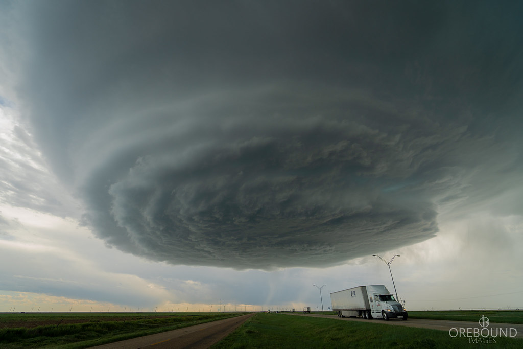
Vega, TX LP Supercell
by OREBOUND IMAGES, on Flickr


Tescott KS Wedge Tornado
by OREBOUND IMAGES, on Flickr


Minneola Kansas Tornadoes
by OREBOUND IMAGES, on Flickr
 
Advertisement
I think you've picked up a few subscribers here too.
Great shots. Well done.
Keen to hear how the season unfolds for you.

Ha thanks mate, I better make sure I put together some nice content for all three of you now hey! ;)

Hopefully a couple of the other guys heading over start posting here too.
 
Outstanding images @Orebound Looking forward to your journey over there. Be Safe, sadly i lost a good mate last year over there when he was hit by a car.

Sorry to hear that @Gleno71 I assume you're talking about Dale? If so, I was fortunate enough to meet him for the first time last year. We had a mutual friend (Ty Shmitt) and we all caught up in far western Kansas on a chase one day. I remember how excited he was to finally be there for the first time. His photos were incredible, such a sad loss.

On the subject of Ty, here's some of his work from last season. A good mate and an extremely talented photographer, he chased with Dale a fair bit last season.


Thanks everyone for the kind words, hopefully we can snare some nice images throughout the season to keep the thread ticking along.


Yes was Dale, we used to chase storms together around the SE QLD region during storm season, he was so passionate about severe weather and photography in general.
 
Well thought I better get back into this thread. Will be particularly difficult going back to virtual targeting after my first alley season last year. Wasn't the best tornado wise, given so many were rain wrapped or in the dark or roads were cut by wretched floodwaters given the insane rain but managed about 11 in total mixed with a couple of dreadful busts (Lawrence KS one especially, but the McCook one grates me the most as that was our original target before getting sidetracked by other issues). Least we got the Farnham/Cozad one that day in the end. Certainly storm wise though it was pretty impressive, think we only had 3-4 rest or down days in nearly 6 weeks!

Brilliant images as always Orebound, im sure this thread will cop many more.

Also indeed it was very sad about Dale last year. In his first trip as well like myself, how very cruel and tragic. I didn't meet him personally but drove past him a few times and saw him in the car etc.

TS :cool:


Great to see you here Rowland! You'll be missed on the plains this year man but hopefully you can get back real soon. I shall look forward to your virtual targets as I always do and no doubt I'll be spamming you with some close tornado intercepts! ;)

Ah McCook huh... as you know I targeted away from Nebraska that day on an apparently unbreachable capped dryline in southern Kansas - the chaser convergence up in NE was not my cuppa tea but I reckon you'll agree the Minneola KS tornado was some consolation :thumbs:


(excuse soft focus in this video!)
 
  • Like
Reactions: trappers and GS
Already looking at the radars and only 2 days in over there and it’s starting to look good. Gorgeous hook to the E of Crofton, Kentucky not long ago

I’ll be watching with anticipation here as well, I followed Rowland and cameron on their trip last year and be doing the same
 
  • Like
Reactions: Ultrasteez
Hello Folks:
Yes, truly sad news from the storms in central Tennessee overnight.
4 Tennessee counties were hard hit--including Davidson County, where Nashville is located. Also hard hit was Putnam County (to the East of Nashville), where the city of Cookeville was very hard hit. Putnam County was one of 2 Tennessee counties that had apparent F-3 tornadoes (winds of 136-165MPH/219-265.7KPH). Watching footage (on the Weather Channel) of the terrible twister damage in neighborhoods of Nashville and in the town of Cookeville. Some houses leveled to their foundations. At current, it is unclear how many twister there were; as twisters were reported several times along a 145-mile/233.4-kilometer stretch. The town of Camden was hit just after 11PM CST (Sunday); Nashville was struck just after 12Midnight & Cookeville was hit shortly before 2AM.
Thus far at least 22 people have perished:
16 in Putnam County; 3 in Wilson County; 2 in Davidson County and 1 in Benton County.
Nashville's Germantown area, Donelson neighborhood and parts of east Nashville were hard hit. TWC's Mike Seidel has been giving reports from the Buena Vista neighborhood of Nashville for much of the day.
At least 50,100 power outages were reported statewide early Tuesday, including 47,000 reported by the Nashville Electric Service.
Update (now 4:38PM CDT Tuesday), 25 fatalities are now reported with this outbreak in Tennessee. It'll be interesting to see the storm reports on the SPC site.
Here's a youtube vid of drone footage of the destruction in Nashville, TN., Please see:

My thoughts & prayers go out to those impacted. The damage in this vid is around 450 miles/724.6 kilometers ENE of my town.
 
Last edited:
Yes unfortunately these very early season Dixie Alley events have a long history of being big contributors to the annual tornado fatality numbers simply due to the much increased population density down there compared to most of the traditional plains states where we will be seeing the big numbers of tornado events in the coming months. This particular event has been assessed as an EF4 that tracked in excess of 50 miles so certainly a long tracked and violent tornado by any standard.


ESTJ26WWkAEj4hm.jpeg.jpg

IMG-20200305-WA0001.jpg

A few of the seasonal outlooks are starting to suggest an average to above average season so unfortunately there will be many more severe events to come across Dixie first and then of course the more traditional Tornado Alley states as we move into late April onwards.

2020 Seasonal Tornado Outlook

We will be arriving towards the middle of next month and as much as we love witnessing some of these amazing events we certainly take no pleasure in seeing them occur in any populated areas. Thankfully the large percentage of tornadoes each season do tend to occur in the much less populated regions of the Great Plains, though even then they have a sometimes uncanny habit of picking off even the smallest population centres.

I often refer to the below image as an example of pure bad luck. This was from an EF3 tornado we chased last season that managed to stay on the ground for almost 100 miles in SW Kansas, passing through mostly open farmland. The scouring in the fields shows the tornado track deviate dramatically to strike the only farmhouse within 5 miles. Thankfully the home owners had fled after seeing the tornado approach.

20191025_180538[2060].jpg
 
Last edited:
H

My thoughts & prayers go out to those impacted. The damage in this vid is around 450 miles/724.6 kilometers ENE of my town.

Prayers to who? The one that made the world in seven days is such an arsehole it added tornados to keep us on our toes?
 
Hello Folks:
Just after 5PM Thursday here. Watching the Weather Channel and they are interviewing a woman who survived the tornado with a good deal of debris in her yard. Among the debris was a "Terminal" sign, which came from John C. Tune Airport. This general aviation airport--to the West of downtown Nashville--is 20 miles/32.2 kilometers to the West of where this sign landed! This airport (JWN) sustained at least $US90 Million in damage (not including aircraft).
Also, just now saw (5:48PM Thursday) where this twister launched a car into a 3rd floor window of a nearby apartment building!
 
Last edited:
Teeneesee and surrounds the interest areas for severe weather with the Storm Predic Centre going a 10% chance of EF2-EF5 tornadoes.

Quote from the SPC:

" SPC AC 120503

Day 1 Convective Outlook
NWS Storm Prediction Center Norman OK
1203 AM CDT Thu Mar 12 2020
Valid 121200Z - 131200Z

...THERE IS AN ENHANCED RISK OF SEVERE THUNDERSTORMS ACROSS PARTS OF
THE MID MISSISSIPPI...OHIO AND TENNESSEE VALLEYS...

...SUMMARY...
Severe thunderstorms with tornadoes, large hail and wind damage are likely across parts of the mid Mississippi, Ohio and Tennessee. Valleys this afternoon and evening. Isolated severe storms will also be possible in parts of the Arklatex and Ozarks. A few marginally severe storms could occur in the Desert Southwest.

...Arklatex/Mid Mississippi Valley/Ohio and Tennessee Valleys...
An upper-level trough will move eastward across the Great Plains today as a 75 to 100 kt mid-level jet moves across the central Plains and upper Mississippi Valley. A secondary 60 to 80 kt mid-level jet will move into the lower Ohio Valley. Increasing low-level moisture ahead of a cold front will result in surface dewpoints in the 60 to 65 F range from southeast Missouri and northeast Arkansas eastward across western Kentucky and Tennessee. This will lead to the development of an east to west corridor of instability by afternoon. Thunderstorms are forecast to first develop across south-central Missouri this morning and spread eastward into western Kentucky and northwest Tennessee by early to mid afternoon. The instability combined with strong deep-layer shear will be favorable for severe storms.

Concerning the finer-scale details, scattered thunderstorms should develop near a surface low in south-central Missouri around midday with this convection moving eastward across southern Illinois and into western Kentucky early this afternoon. This activity should stay along and to the south of a warm front extending eastward from the surface low. Cells that can move into the air south of the warm front will likely be surface-based, and will have the greatest chance to become severe. Forecast soundings near Paducah this afternoon show MLCAPE near 750 J/kg and 0-6 km shear of 60-65 kt. Hodographs show strong speed shear in the lowest 1 km AGL with strong directional shear below 850 mb. This will be favorable for
supercells and tornadoes. The tornado threat will likely be greatest in association with the 850 mb and 500 mb jet couplet. Storm relative helicities of 450 to 550 m2/s2 will support a threat for significant tornadoes as well. Supercells that move along and parallel to the warm front should have the greatest potential for tornadoes. A threat for large hail and wind damage will also be associated with supercells. A wind-damage threat will also be possible with bowing line segments.

Further southwest across the Arklatex and Ozarks, a cold front will advance southeastward this afternoon. Model forecast suggest that a pocket of instability will develop ahead of the front. Convection that initiates along and ahead of the front will move east-southeastward across the region. Surface dewpoints in the mid 60s F, MLCAPE of 500 to 750 J/kg and 0-6 km shear near 50 kt will likely support the development of isolated severe storms with potential for wind damage and hail.

...Desert Southwest...
An upper-level low will move slowly eastward off the coast of southern California. A 75 to 100 kt mid-level jet will move through the southeastern part of the system with the exit region affecting the Desert Southwest today. A surface low will deepen beneath the mid-level jet as a moist airmass with surface dewpoints in the 55 to 60 F range remains in place across southeast California and southwest Arizona. Surface heating will allow a pocket of instability to develop by afternoon with MLCAPE reaching 500 J/kg in many locations. As scattered thunderstorms develop this afternoon, the instability combined with moderate deep-layer shear should be sufficient for a marginal severe threat. Wind damage and hail will be possible with the stronger multicell clusters and short line-segments.
..Broyles/Wendt.. 03/12/2020 "


Defintely going to be an interesting day ahead for them, only recovering from the last lot of tornadoes that hit not long ago.
 
  • Like
Reactions: Orebound
Not that I am planning anything anytime soon but could you point us in the direction of who you would possible recommend that organises these chases. I would be curious on costs involved as it is something I would love to do one day.
 
Not that I am planning anything anytime soon but could you point us in the direction of who you would possible recommend that organises these chases. I would be curious on costs involved as it is something I would love to do one day.

G'Day @chunky I've personally never used any of the chase tour companies as we do it all ourselves but I can assure you there is no shortage of companies out there doing guided tours. These range from small single person operators doing more personal tours to the larger operations like Silver Linings and Cloud 9 etc. I do however have a good mate who I've chased with on occasions over the years that runs the more personal type tours and is extremely talented at finding tornadoes, there is some information on his prices etc here Manitoba Storm Chasers
 
  • Like
Reactions: POW Hungry
G'Day @chunky I've personally never used any of the chase tour companies as we do it all ourselves but I can assure you there is no shortage of companies out there doing guided tours. These range from small single person operators doing more personal tours to the larger operations like Silver Linings and Cloud 9 etc. I do however have a good mate who I've chased with on occasions over the years that runs the more personal type tours and is extremely talented at finding tornadoes, there is some information on his prices etc here Manitoba Storm Chasers
As never having done it I'd be a bit scared, not know how to find them, not know an escape route etc etc.
 
As never having done it I'd be a bit scared, not know how to find them, not know an escape route etc etc.

No worries @chunky Only advice I would offer is to do your research in regards to some of these tour operators as there is a few fairly dodgy ones getting around over there these days too, that being said most are very good at what they do and utilizing their services is probably the best way of learning how it's all done over there. Finding severe storms, and in particular tornadoes is nowhere near is easy it is made to appear and it generally takes more than a passing interest in forecasting to put oneself in the right location to experience the best of tornado alley. Plenty have come on any given year and not seen anything remotely close to a tornado I can assure you!
 
Looking rather volatile across the Mid West today....western IL, E IA especially.

We have a strong dynamic setup with a deepening lee cyclone off the rockies rapidly translating eastwards with sfc pressures into the mid 980's and a massive mid and upper level jet aloft. Numbers at play here, 25-30knot SFC winds, 40-50knots 850hPa LLJ, 60-70knots 700hPa, 90-100knot 500hPa and 140-160knot 300-200hPa. Powerful winds and enormous evacuation of mass and lift. Such lift that waves of elevated storms are ongoing in the early hours through MO translating NE. A warm front extends across IL lifting north but this may be a little disrupted through the centre and eastern portions but the western section, especially closer to the sfc low over IA meeting the cold front axis with some backed winds will be a focus.

It's a tricky one as we have more isolated supercells closer to the sfc low with more E sfc flow over central to NE IA, but the greater instability and lower lcl's off the back of the morning convection in that warm moist sector between warm front and cold front, subtending NW with SE sfc flow looks bloody fine to me. Issue will be storm speed (off the charts) and the big fat Mississippi River.....IA initiation of the strongest supercells seems likely, more likely SE IA but trying to start west of the river and look for a crossing may be an issue, especially in this current world so will remain east of the river in IL and let the storms come to me....thinking somewhere around Roseville IL to St.Augustine IL for a target but geez it's a broad area with 60-70mph storm modes. Be hard for that perfect intercept so may need to get well ahead even more NE but time will tell.

TS :cool:
 
Nice post Rowland.

Volatile situation ongoing up in IL but geez that Jonesboro AR thing looks like it could be quite significant, the CC sig looks nasty.


Obviously with the current COVID-19 situation we will not be doing our annual alley season this year which is unfortunate but completely understandable. So for the first time in many years I'll have to settle for the virtual chase thing myself :cry:

We'll be back next year with bells on assuming this thing is under control by then.
 
  • Like
Reactions: POW Hungry
Shooting from the hip here with a quick look but somewhere around Benjamin TX to Seymour TX for the enhanced risk tomorrow, couple of rounds of storms off the dryline area, should be discrete enough, bit of a bulge there and some backed winds which may enhance low level hodo's a tad.

Then a big drive east at night for the big day!

TS :cool:

Nothing wrong with the target region there mate with a few nice sups transiting the area. One cell in particular near Haskell went close before appearing to get undercut. The dreaded VBV profiles looked to take care of sustained low level structures and thus minimized the tornado threat but I'd have certainly played a similar area myself.
 
Eyeing the radar and Tx is away big time. Some tasty couplets appearing as well, only early and the worst is yet to come.
I will go Cleveland MS, El Dorado AR, Tri Point of Louisana, Mississippi and Arkansas, Greenville MS. Many soundings there pegged by the past few runs of HRRR show PDSTOR so hanging around that area, so just slightly N of the ENHANCED area made via SPC. NAM looking decent as well. Satellite will be eye candy with some billowing overshoots.
 
Alright enough farting around just spent an hour in google maps trying to find a clearing in MS but thinking around Mathiston MS... was thinking more Brooksville to the SE but sticking NW for now.

Essentially a big day but a classic dirty Dixie day with strong tornado potential anywhere from E TX through LA AR MS into AL later on. Multiple rounds of storms but primarily there will be a broad MCS cluster from nocturnal storms currently on going which will be a focus for QLCS events early on before sfc based convection takes over.....and I'm eyeing off a lead/rogue cluster on an enhanced area of backed winds juxtaposed to the more linear feature advancing from the west, however eventually may be overtaken. More backed winds here in nothing short of violent kinematics...just the best chance to get a clean cell let alone clear views with the jungles all around. Could easily be many nasty tornadoes...in particular SE AR NE LA and W to N MS....into NW AL but tail end charlies may be a play down south out in the open but at the expense of larger critical angles near 90degrees more of these are with less sfc backing and smaller degrees in the 40-50 range. Most mode potential is linear to embedded but discrete storms in this envrionment will very quickly take old, especially in the 400-500SRH ahead of the line along that favourable area. These more discrete storms may take quite a bit more time to get going, even after many tornadoes have already occured but I want to be able to see the damn things so this gives me the best chance.

Praying for no deaths but potential is sadly there for some....

TS :cool:
 
  • Like
Reactions: Orebound
Hello Folks:
There are PDS (Particularly Dangerous Situation) issued for the S part of the US. The (US) Weather Channel will not be showing their peripheral shows today (Sunday) in order to stay on top of this Severe Weather Outbreak. They give TORCOM scores of 7 (7 in 10 chance of seeing a twister within 20-50 miles of a point) in N parts of Alabama & W parts of Mississippi as the evening progresses (currently 12:36PM CDT Sunday here). After 1.10"/27.9mm rain here on Saturday; I've received a further 1.60"/40.6mm rain today in AM thundershowers. The rain stopped around an hour ago & now the sun (temp. here now is around 60F/15.5C) looks like trying to show through the clouds. As per the Weather Channel, my area looks likely to see large hail in a few hours, as the back edge of the Low-Pressure crosses my area. My town doesn't get that much hail & what hail we do get is usually small.
Looks like another interesting--and potentially damaging & deadly--evening & night. Happy Easter to All & Keeping An Eye On The Sky!
 
  • Like
Reactions: Claude Cat
Detailed damage survey summary from the Bassfield/Covington County/Soso/Moss/Heidelberg/Pachuta EF-4 tornado

EV1vCKAUEAENnTW.png


A further severe WX event likely through Dixie on Sunday US time. Perhaps not the low-level support for a widespread tornado outbreak but no doubt a few QLCS/LEWP spin-ups at the very least.

day2probotlk_0600_torn.gif

Day 2 Convective Outlook
NWS Storm Prediction Center Norman OK
0100 AM CDT Sat Apr 18 2020

Valid 191200Z - 201200Z

...THERE IS AN ENHANCED RISK OF SEVERE THUNDERSTORMS FROM THE SABINE
RIVER EASTWARD INTO SOUTH CAROLINA...

...SUMMARY...
Severe storms are likely Sunday from east Texas to South Carolina.
The greatest threat appears to be from Louisiana to Georgia, with
significant severe including tornadoes and damaging winds. Large
hail is likely over much of the area as well.

...Synopsis...
A progressive shortwave trough will move from the southern Plains
into the lower MS Valley during the day, and will continue to the
GA/SC/NC coast by Monday morning. The entire southeastern region
will be under the influence of strong westerly winds aloft which
will strengthen as the upper trough approaches. Southwesterly 850 mb
winds will increase in response to the wave, reaching 50+ kt by 00Z
from MS eastward to the coast.

At the surface, low pressure will develop near the ArkLaTex by late
afternoon as a warm front lifts north across the southeastern
states, oriented roughly from southern AR into northern MS, AL, and
GA at 18Z. Meanwhile, a cold front/dryline will develop over east
TX. Across the warm sector, rich moisture with 65-70 F dewpoints
will result in moderate instability. The low, likely associated with
widespread convection, will translate eastward along the synoptic
front overnight, reaching NC by 12Z Monday.

...Southeastern states...
Substantial instability will already be in place Sunday morning from
TX into the lower MS Valley, with rapid destabilization expected
behind the warm front farther east into GA. Midlevel lapse rates
aloft will be modestly steep, averaging 6.5 to 7.0 C/km. Early day
storms related to warm advection will be present over AL and GA, and
they will likely be elevated with perhaps a hail threat initially.
As the air mass warms, a wind or tornado threat could develop in the
vicinity of this activity as it continues east.

To the west, storms are likely to be severe by 18Z near the Sabine
Valley/ArkLaTex. Here, long hodographs but modest low-level SRH may
result in cells capable of very large hail, and perhaps an eventual
MCS with damaging-wind threat. A severe wind corridor may thus
develop during the day across northern MS, AL, and GA.

There is also a threat of daytime supercells, possibly tornadic, as
the small capping inversion is eroded by early afternoon. During the
evening and overnight, low-level shear will increase further, and
models suggest southern AL into GA may be a favored area for
tornadoes. Bows or isolated supercells are possible into SC early
Monday morning as the relatively cooler air mass is destroyed by the
warm front.

..Jewell.. 04/18/2020
 
  • Like
Reactions: Claude Cat
Fairly significant upgrade in this event with many of the global and CAM mesoscale models depicting a much more vigorous surface low with better backing and less suggesting the linear storm modes they were a day or so ago. With supercells now appearing to remain discreet across the open warm sector in an environment overtopped by very strong mid-level shear it now appears likely there will be potential for some stronger long-tracked tornadoes, particularly across LA and MS before upscale growth further east sees more probable bowing segments and linear structures as the primary storm modes.